IMAGES TAKEN NEAR TO
Milton Street, POLEGATE, BN26 5RP
Introduction
This page details the photographs taken nearby to BN26 5RP by members of the Geograph project.
The Geograph project started in 2005 with the aim of publishing, organising and preserving representative images for every square kilometre of Great Britain, Ireland and the Isle of Man.

There are currently over 7.5m images from over14,400 individuals and you can help contribute to the project by visiting https://www.geograph.org.uk
Image Map
Images are licensed for reuse under creativecommons.org/licenses/by-sa/2.0
Notes
- Clicking on the map will re-center to the selected point.
- The higher the marker number, the further away the image location is from the centre of the postcode.
Image Listing (25 Images Found)
Images are licensed for reuse under creativecommons.org/licenses/by-sa/2.0
Image
Details
Distance
1
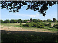
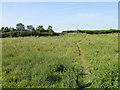
High Field
The name of the field according to Arlington's 1843 tithe map viewed from the junction of footpaths next to the A27. The clump of bushes in the foreground marks the site of a spring whilst the house in view beyond it is Merrivale that lies at the northern end of the lane to Milton Street.
Image: © Simon Carey
Taken: 2 Jun 2011
0.07 miles
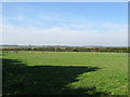
2
Footpath through a thistly field
There is supposed to be a public footpath running along beside the hedgerow, but scant use has been made of it. This is probably because it only goes to the very busy A27 which has no sidewalks.
Image: © Robin Webster
Taken: 11 Sep 2011
0.10 miles
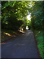
3

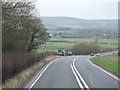
SW on Milton Street towards Milton Street
The Wealdway turns left just before the fencing.
Image: © Dave Spicer
Taken: 9 Jul 2012
0.12 miles
4

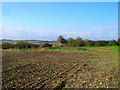
Higs Field
The name of the field according to Arlington's 1843 tithe map viewed from the unnamed lane that heads south from the A27 to the hamlet of Milton Street.
Image: © Simon Carey
Taken: 1 Oct 2011
0.13 miles
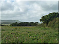
5
Three Cornered Field
The name of the field according to Arlington's 1843 tithe map which was relatively new at the time of that survey as it had been formed by the construction in 1819 of the new Lewes to Eastbourne turnpike that is now the current A27.
Image: © Simon Carey
Taken: 1 Oct 2011
0.14 miles

7
Milton Street
A straggling hamlet that lies along the lane to Milton Court from which it derives its name. Viewed from the point when the bridleway to Burlough Castle leaves the lane.
Image: © Simon Carey
Taken: 24 Aug 2008
0.14 miles
8
Shaw Piece
The name of the field according to Arlington's 1843 tithe map which is squeezed between an unnamed tributary of the Cuckmere River and the A27 which lies beyond the stile at the top of the slope.
Image: © Simon Carey
Taken: 2 Jun 2011
0.15 miles
10
New Barn
Just north of the point where the bridleway from Milton Street to Burlough Castle meets the footpath that heads north to the A27.
Image: © Simon Carey
Taken: 24 Aug 2008
0.16 miles