IMAGES TAKEN NEAR TO
Wannock Road, POLEGATE, BN26 5EA
Introduction
This page details the photographs taken nearby to Wannock Road, BN26 5EA by members of the Geograph project.
The Geograph project started in 2005 with the aim of publishing, organising and preserving representative images for every square kilometre of Great Britain, Ireland and the Isle of Man.

There are currently over 7.5m images from over14,400 individuals and you can help contribute to the project by visiting https://www.geograph.org.uk
Image Map
Images are licensed for reuse under creativecommons.org/licenses/by-sa/2.0
Notes
- Clicking on the map will re-center to the selected point.
- The higher the marker number, the further away the image location is from the centre of the postcode.
Image Listing (47 Images Found)
Images are licensed for reuse under creativecommons.org/licenses/by-sa/2.0
Image
Details
Distance
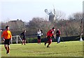
1
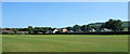
Polegate War Memorial Ground - Polegate Town FC
The ground could have had a medical centre built on it, but further investigation showed it to be in trust as a war memorial which stopped any building on the land. Here Polegate in orange play a local team in the East Sussex League One. Polegate windmill is seen in the background.
Image: © nick macneill
Taken: 21 Mar 2009
0.07 miles
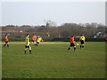
2
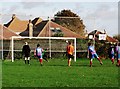
The War Memorial Recreation Ground, Polegate
The game is between Polegate FC and Cuckfield Rangers in the Mid Sussex League 'Championship'. Cuckfield in red won the match two goals to one.
Image: © nick macneill
Taken: 25 Feb 2012
0.08 miles
3
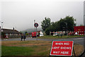
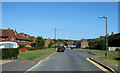
Wannock Road Polegate
Near its junction with the A2270.
Image: © Dave Spicer
Taken: 13 Sep 2012
0.08 miles
4
Polegate Recreation Ground, Wannock Road, Poelgate
The sweeps of Polegate Windmill can be seen behind the trees on the left. Combe Hill is on the right.
Image: © Kevin Gordon
Taken: 22 Jul 2008
0.09 miles
5
Penalty hits the bar, Polegate
The match is between Polegate Town and Barnham FC in the Sussex County Intermedeiate Cup. Polegate did an act of 'giant killing' in beating their County League opponents by three goals to two. This superb contest could have finished with a Barnham win if they had not missed both of their penalties. Polegate are in orange.
Image: © nick macneill
Taken: 27 Oct 2012
0.09 miles
6
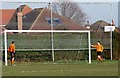
Game over, Polegate FC
At the end of the match two players dismantle the goal.
Image: © nick macneill
Taken: 25 Feb 2012
0.10 miles
7
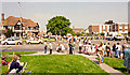
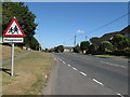
Polegate crossroads and carnival procession 2
Looking north-east towards Polegate High Street. The building on the left is the ‘Horse and Groom’ pub. The carnival procession has caused the police to close the busy main road through to Eastbourne which runs from left to right in the picture. July 1985.
Image: © Andrew Huggett
Taken: Unknown
0.12 miles
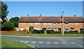
8
Southfield, Polegate
When I lived here in the 1960s there was a telephone box close to the telegraph pole. Originally a council estate, Southfield has wide roads and pleasant tile hung houses.
Image: © Kevin Gordon
Taken: 22 Jul 2008
0.12 miles
9
Southfield, Polegate
Southfield is an estate built in the late 1950s by the council. Initially the left hand side of this circular road was built with the right hand (southern) following a few years later. The house in the centre was my home in the 1960s.
Image: © Kevin Gordon
Taken: 22 Jul 2008
0.14 miles