IMAGES TAKEN NEAR TO
Arundel Road, BRIGHTON, BN2 5TX
Introduction
This page details the photographs taken nearby to Arundel Road, BN2 5TX by members of the Geograph project.
The Geograph project started in 2005 with the aim of publishing, organising and preserving representative images for every square kilometre of Great Britain, Ireland and the Isle of Man.

There are currently over 7.5m images from over14,400 individuals and you can help contribute to the project by visiting https://www.geograph.org.uk
Image Map
Images are licensed for reuse under creativecommons.org/licenses/by-sa/2.0
Notes
- Clicking on the map will re-center to the selected point.
- The higher the marker number, the further away the image location is from the centre of the postcode.
Image Listing (212 Images Found)
Images are licensed for reuse under creativecommons.org/licenses/by-sa/2.0
Image
Details
Distance
1
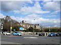
Arundel Road Roundabout
At the junction with Roedean Road and Bristol Gardens. The Brighton Steiner School http://www.brightonsteinerschool.org.uk/contact.html is in the background
Image: © Paul Gillett
Taken: 14 Mar 2013
0.03 miles
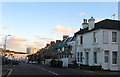
2
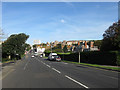
Roedean Road
The B2118 heading towards the junction with Arundel Road and Whitehawk Road. Originally built as a replacement for the old coast road to Rottingdean which was closed in 1895 due to continual cliff collapses caused by coastal erosion and remained so until the current Marine Drive was constructed in 1932 simultaneously with the new coastal defences known as the Undercliff Walk. The tall building in the distance is Thomas Kemp Tower, part of the Royal Sussex Hospital.
Image: © Simon Carey
Taken: 29 Aug 2011
0.03 miles
3
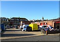
Bell Tower Industrial Estate, Kemp Town, Brighton
Accessed via boundary Road the small industrial estate occupies the site of the former St Mark's Church of England Primary School which moved here from Image in the late 1890s and finally vacated in the early 1980s with the school buildings demolished in 1982. See http://www.bygones.org.uk/page_id__297.aspx for demolition pictures.
Image: © Simon Carey
Taken: 13 Nov 2015
0.04 miles
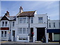
4
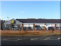
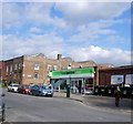
Lidl, Arundel Road, Kemp Town, Brighton
Originally the site of Wilson's Laundry that operated here from the 1850s until its closure in 1992 with the buildings cleared away three years later. The firm continued its dry cleaning business until 2003 when the last members of the Wilson family decided to shut it down for good. Not sure when Lidl arrived but it was over a decade ago.
Image: © Simon Carey
Taken: 31 Dec 2015
0.04 miles
5
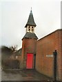
Bell Tower
On the Bell Tower Industrial Estate near to Brighton Marina
Image: © Paul Gillett
Taken: 5 Feb 2011
0.04 miles
7
Eastern Road, Kemp Town, Brighton
A view of the road from the junction with Arundel Place on the right. A major arterial route that begins as a continuation of Edward Street to the west and ends at Arundel Street visible in the distance.
Image: © Simon Carey
Taken: 13 Nov 2015
0.07 miles
8
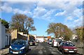
Bristol Place, Kemp Town, Brighton
The road runs between Eastern Road and Bristol Road but has never been residential, the western side contains the rear entrances to houses in Sussex Square whilst for many years the eastern side was a nursery which now contains a small blocks of flats. Hollingbourne Court.
Image: © Simon Carey
Taken: 13 Nov 2015
0.08 miles
10
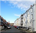
Arundel Street, Kemp Town, Brighton
A residential road that runs between Marine Parade and Boundary Road. The eastern side was developed in the late 1870s but the western side was not completed until the 1920s. Viewed from the junction with De Courcel Road.
Image: © Simon Carey
Taken: 13 Nov 2015
0.08 miles