IMAGES TAKEN NEAR TO
Roedean Heights, BRIGHTON, BN2 5SA
Introduction
This page details the photographs taken nearby to Roedean Heights, BN2 5SA by members of the Geograph project.
The Geograph project started in 2005 with the aim of publishing, organising and preserving representative images for every square kilometre of Great Britain, Ireland and the Isle of Man.

There are currently over 7.5m images from over14,400 individuals and you can help contribute to the project by visiting https://www.geograph.org.uk
Image Map
Images are licensed for reuse under creativecommons.org/licenses/by-sa/2.0
Notes
- Clicking on the map will re-center to the selected point.
- The higher the marker number, the further away the image location is from the centre of the postcode.
Image Listing (93 Images Found)
Images are licensed for reuse under creativecommons.org/licenses/by-sa/2.0
Image
Details
Distance
1
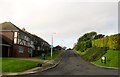
Roedean Heights, Roedean
A cul de sac off Roedean Crescent built sometime in the 1980s on the site of a Downside, a large house with extensive grounds.
Image: © Simon Carey
Taken: 23 Dec 2015
0.01 miles
2
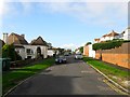
The Cliff, Black Rock, Brighton
A residential road that runs from Roedean Road to Cliff Approach that was laid out around 1910 with Image built soon after with the rest developed intermittently after 1919.
Image: © Simon Carey
Taken: 23 Dec 2015
0.09 miles
3
Roedean Miniature Golf Course
The 18 hole course was opened in 1957 and occupies the angle between the A259 and B2118. It was reduced by two holes in 1988 when the access roads to Brighton Marina were improved.
Image: © Simon Carey
Taken: 6 Jan 2010
0.10 miles
4
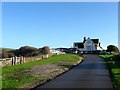
Clubhouse, East Brighton Golf Club
Erected in 1897 at the same time as the original Kemp Town Golf Club changed its name to East Brighton. The course extends over Red Hill and into the western side of Wick Bottom. One of seven that can be found on the Downs above the conurbation of Brighton and Hove.
Image: © Simon Carey
Taken: 31 Dec 2015
0.11 miles
5
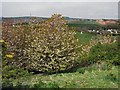
Blossoms on hill overlooking East Brighton Park
Image: © Paul Gillett
Taken: 1 May 2010
0.13 miles
6
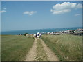
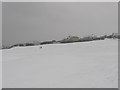
Bridleway - East of East Brighton Park
Heading Southwest, on this bright sunny day the sea looks very inviting
Image: © Paul Gillett
Taken: 24 Jun 2009
0.13 miles
8
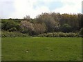
Blossom in East Brighton Park
Near the South West of the Park
Image: © Paul Gillett
Taken: 1 May 2010
0.16 miles
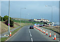
9
The Long Walk Home
The deteriorating weather has made the A259 coast road with its switchback like ride through Ovingdean, Rottingdean and Saltdean too dangerous for public transport with the consequence that all bus services were suspended along this route. The girl in view has a few miles of pavement pounding to do before reaching one of the above suburbs
Image: © Simon Carey
Taken: 6 Jan 2010
0.17 miles
10
East Brighton Cricket Pavilion
View West includes Cricket Pavilion/Cafe in middle distance. Mast on hill is location of Brighton (Horse) racecourse.
Image: © Mark Arrowsmith
Taken: Unknown
0.17 miles