IMAGES TAKEN NEAR TO
Roedean Terrace, BRIGHTON, BN2 5RN
Introduction
This page details the photographs taken nearby to Roedean Terrace, BN2 5RN by members of the Geograph project.
The Geograph project started in 2005 with the aim of publishing, organising and preserving representative images for every square kilometre of Great Britain, Ireland and the Isle of Man.

There are currently over 7.5m images from over14,400 individuals and you can help contribute to the project by visiting https://www.geograph.org.uk
Image Map
Images are licensed for reuse under creativecommons.org/licenses/by-sa/2.0
Notes
- Clicking on the map will re-center to the selected point.
- The higher the marker number, the further away the image location is from the centre of the postcode.
Image Listing (75 Images Found)
Images are licensed for reuse under creativecommons.org/licenses/by-sa/2.0
Image
Details
Distance
1
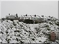
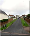
Roedean Terrace
Originally built as coastguard cottages in the early 1900 with the house on the left being the former watchhouse, Initially an isolated spot the cottages ended up being built around by the new suburb of Roedean in the 1930s. At least they still retain their view of the sea.
Image: © Simon Carey
Taken: 6 Jan 2010
0.03 miles
2
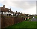
Roedean Way, Roedean
A residential road at the end of which is the entrance to Roedean School. The road runs along the old parish boundary between Ovingdean to the left and Rottingdean to the right and was initially developed in the 1930s when the houses in view were built and completed at the eastern end by the 1960s.
Image: © Simon Carey
Taken: 23 Dec 2015
0.04 miles
3
Roedean Crescent, Roedean
A residential road that runs from Roedean Road to Roedean Vale and was started in the 1930s and completed at its eastern end by the late 1960s.
Image: © Simon Carey
Taken: 23 Dec 2015
0.04 miles
4
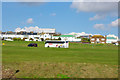
Houses on Roedean Way
Looking across a miniature golf course.
Image: © Robin Webster
Taken: 2 Mar 2010
0.04 miles
5
Roedean Path, Roedean
A road that links Roedean Way to Roedean Crescent that originally was a path until surfaced in the late 1950s/early 1960s as the suburb of Roedean extended eastwards. There are no houses on this street though it does provide access for Roedean Terrace which is out of shot to the right.
Image: © Simon Carey
Taken: 23 Dec 2015
0.04 miles
6
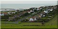
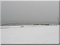
Roedean
Looking west from Cattle Hill. The western breakwater of the Brighton Marina is visible top left.
Image: © Janine Forbes
Taken: 7 Nov 2005
0.06 miles
9
Roedean Way
Residential street in the Roedean suburb which starts at Roedean Road and finishes at the junction of the entrance to Roedean School and Roedean Vale which heads north.
Image: © Simon Carey
Taken: 6 Jan 2010
0.07 miles
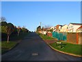
10
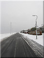
Towards Brighton Marina
The car in the centre of the photo is not stuck in a snowdrift but is travelling down Roedean Road which has banked verges either side. Taken from Roedean Way the normally green space between the two roads is open and sometimes used as a putting green, beyond the car is Roedean Pitch and Putt golf course which leads down to the A259 then cliff top below which is the Brighton Marina.
Image: © Simon Carey
Taken: 6 Jan 2010
0.07 miles