IMAGES TAKEN NEAR TO
Kingston Way, SEAFORD, BN25 4NG
Introduction
This page details the photographs taken nearby to Kingston Way, BN25 4NG by members of the Geograph project.
The Geograph project started in 2005 with the aim of publishing, organising and preserving representative images for every square kilometre of Great Britain, Ireland and the Isle of Man.

There are currently over 7.5m images from over14,400 individuals and you can help contribute to the project by visiting https://www.geograph.org.uk
Image Map (Loading...)


Getting Data...Please wait
Leaflet Map data © OpenStreetMap
Images are licensed for reuse under creativecommons.org/licenses/by-sa/2.0
Notes
- Clicking on the map will re-center to the selected point.
- The higher the marker number, the further away the image location is from the centre of the postcode.
Image Listing (22 Images Found)
Images are licensed for reuse under creativecommons.org/licenses/by-sa/2.0
Image
Details
Distance
1
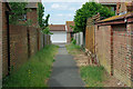
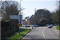
The footway between Willow Drive and Rowan Close
This area is a bewildering maze of roads and closes. This is the only direct way between two of the several branching sets of roads, named after trees. Road vehicles have to return to the main road and start again at another entry point into the maze.
Image: © Robin Webster
Taken: 15 Jun 2010
0.08 miles
2
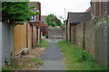
The footway between Rowan Close and Willow Drive
This area is a bewildering maze of roads and closes. This is the only direct way between two of the several branching sets of roads, appropriately named after trees. Road vehicles have to return to the main road and start again at another entry point into the maze.
Image: © Robin Webster
Taken: 15 Jun 2010
0.10 miles
3
Surface air raid shelter, Eastbourne Road, Seaford
The green bank to the front of the house is a former World War Two air raid shelter. One of the two entrances is to the left and is now bricked up the other has been removed and turfed over. This view looks south west from the junction of Eastbourne Road and Stirling Avenue.
Image: © Simon Carey
Taken: 14 Feb 2006
0.10 miles
6
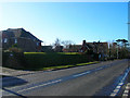
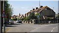
Seaford: housing estate off Sutton Avenue, 1989
View eastward, at Kingston Avenue, off Sutton Avenue approximately where Tyttenhanger Lodge Preparatory School used to be. (I was a pupil there 1936-40).
Image: © Ben Brooksbank
Taken: 11 Jun 1989
0.14 miles
9
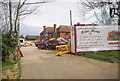
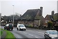
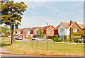
Tudor Manor, Eastbourne Rd
A prestigious development of new housing.
Image: © N Chadwick
Taken: 29 Apr 2010
0.14 miles
10
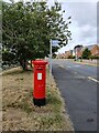
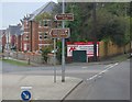
Postbox and Bus stop Sutton Avenue, Seaford
Image: © PAUL FARMER
Taken: 25 Jun 2022
0.14 miles