IMAGES TAKEN NEAR TO
Bishopstone Road, SEAFORD, BN25 2UB
Introduction
This page details the photographs taken nearby to Bishopstone Road, BN25 2UB by members of the Geograph project.
The Geograph project started in 2005 with the aim of publishing, organising and preserving representative images for every square kilometre of Great Britain, Ireland and the Isle of Man.

There are currently over 7.5m images from over14,400 individuals and you can help contribute to the project by visiting https://www.geograph.org.uk
Image Map
Images are licensed for reuse under creativecommons.org/licenses/by-sa/2.0
Notes
- Clicking on the map will re-center to the selected point.
- The higher the marker number, the further away the image location is from the centre of the postcode.
Image Listing (49 Images Found)
Images are licensed for reuse under creativecommons.org/licenses/by-sa/2.0
Image
Details
Distance
1
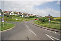
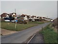
Houses on Bishopstone Road
Towards the A259 road.
Image: © J.Hannan-Briggs
Taken: 12 Apr 2015
0.02 miles
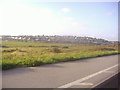
2
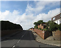
Bishopstone Road
The public highway to Bishopstone and Norton passes the eastern end of Rookery Hill estate. The flint wall on the left is listed and was built to protect the drive to Bishopstone Place which was the original use of this road. Public access to Bishopstone during the medieval period went via Denton and Poverty Bottom before continuing eastwards via Silver Lane to East Blatchington then Seaford.
Image: © Simon Carey
Taken: 26 Aug 2012
0.03 miles
3
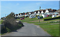
Rookery Hill
The name of the estate built on the hill of the same name. Parts were begun in the late 1930s but the vast majority was not completed until the early 1970s. In the foreground is the former tidal inlet that once connected Bishopstone to the sea whilst between that and the houses a long flint wall is visible a relic from the time Bishopstone Road was little more than a drive to Bishopstone Place. Taken about half an hour after sunrise.
Image: © Simon Carey
Taken: 26 Aug 2012
0.06 miles
4
Rookery Hill
From Marine Parade, Bishopstone
Image: © David Howard
Taken: 12 Sep 2011
0.07 miles
5
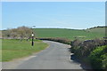
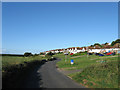
Bishopstone Road
Towards Bishopstone and Norton.
Image: © J.Hannan-Briggs
Taken: 12 Apr 2015
0.08 miles
6
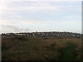
Rookery Hill
The name of the postwar estate built on the hill of the same name.
Image: © Simon Carey
Taken: 15 Nov 2009
0.09 miles
7
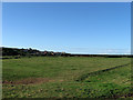
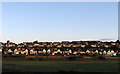
The Long Brook (2)
The name of the field according to Bishopstone's 1844 tithe map. This is the southern end of Image which was once a tidal inlet that linked Bishopstone to the sea and was a football pitch during the 1960s with a pavilion at the bottom end of the field. In the distance to the left is Hawth Hill on which a small estate has been built around Bishopstone station that was opened in 1938.
Image: © Simon Carey
Taken: 26 Aug 2012
0.09 miles
8
Bishopstone Road
People have lived around Bishopstone for thousands of years, evidenced by Neolithic finds, Bronze Age Bowl barrows, Romans remains, a Saxon cemetery and later Medieval buildings . The name means “lands of the Bishop”, in this case the Bishops of Chichester who owned the area from the 8th -16th century
http://www.sussex-opc.org/index.php?k=175&t=Parish
Image: © Paul Gillett
Taken: 28 Mar 2010
0.10 miles
9
St Andrew's Drive, Rookery Hill
Part of the Rookery Hill estate and taken from the junction with Rookery Way. This road was constructed in the 1970s as an access to the parts of the estate.
Image: © Simon Carey
Taken: 28 Aug 2012
0.12 miles