IMAGES TAKEN NEAR TO
Seagrave Close, SEAFORD, BN25 2TW
Introduction
This page details the photographs taken nearby to Seagrave Close, BN25 2TW by members of the Geograph project.
The Geograph project started in 2005 with the aim of publishing, organising and preserving representative images for every square kilometre of Great Britain, Ireland and the Isle of Man.

There are currently over 7.5m images from over14,400 individuals and you can help contribute to the project by visiting https://www.geograph.org.uk
Image Map
Images are licensed for reuse under creativecommons.org/licenses/by-sa/2.0
Notes
- Clicking on the map will re-center to the selected point.
- The higher the marker number, the further away the image location is from the centre of the postcode.
Image Listing (67 Images Found)
Images are licensed for reuse under creativecommons.org/licenses/by-sa/2.0
Image
Details
Distance
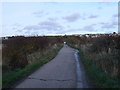
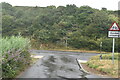
3
Mill Drove
An access road to the deserted village of Tide Mills from the A259 whose junction is in the background. Vehicular access now only extends to a small car park next to the former level crossing, though those travelling on foot can cross and continue to both the former village and the beach. Yesterday's storm has left a stretch of surface water which looks deep but isn't.
Image: © Simon Carey
Taken: 15 Nov 2009
0.07 miles
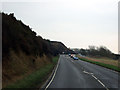
5
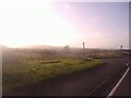
View from Seaford Road, Rookery Hill
The setting sun produced an impressionist style of lighting which could not be avoided. The view is towards Newhaven Harbour and beyond.
Image: © David Howard
Taken: 12 Sep 2011
0.09 miles
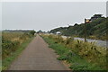
6
Mill Drove
Looking back towards the A259 from the road that leads to Tide Mills, vehicular access is restricted and ends at the level crossing where the gates are now padlocked. The Rookery Hill estate is on the hill above the road.
Image: © Simon Carey
Taken: 23 Oct 2007
0.09 miles
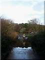
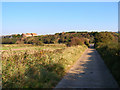
7
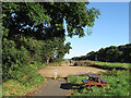
Car park by Cycle Route 2 Seaford to Newhaven
The road, then footpath on the right leads to the Tide Mills near Newhaven Harbour.
Image: © Dave Spicer
Taken: 2 Jun 2012
0.10 miles
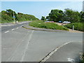
8
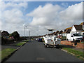
Marine Drive, Rookery Hill
Laid out in the late 1930s as part of a planned estate that was halted due to the outbreak of the Second World War then stalled by tougher planning laws after. However, during the early 1970s the remainder of the state was completed. Where Marine Drive once came to a dead end it now finishes at a junction with St Margaret's Rise.
Image: © Simon Carey
Taken: 28 Aug 2012
0.10 miles
9
Car Park, Mill Drove
Located at the junction of Mill Drove and the A259 and used by those wishing to walk around the Ouse Estuary Nature Reserve, visit Tide Mills or partake in varioue activities on the beach, There is another near the level crossing which is often filled first as that is nearer though this can get equally as busy. The cycle path that links Seaford to Newhaven also runs through it.
Image: © Simon Carey
Taken: 26 Aug 2012
0.11 miles