IMAGES TAKEN NEAR TO
Hawth Hill, SEAFORD, BN25 2RD
Introduction
This page details the photographs taken nearby to Hawth Hill, BN25 2RD by members of the Geograph project.
The Geograph project started in 2005 with the aim of publishing, organising and preserving representative images for every square kilometre of Great Britain, Ireland and the Isle of Man.

There are currently over 7.5m images from over14,400 individuals and you can help contribute to the project by visiting https://www.geograph.org.uk
Image Map
Images are licensed for reuse under creativecommons.org/licenses/by-sa/2.0
Notes
- Clicking on the map will re-center to the selected point.
- The higher the marker number, the further away the image location is from the centre of the postcode.
Image Listing (87 Images Found)
Images are licensed for reuse under creativecommons.org/licenses/by-sa/2.0
Image
Details
Distance
4
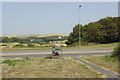
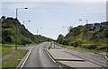
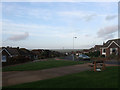
Buckle By-Pass
Two people wait in the bus shelter, oddly positioned at right angles to the road.
Image: © Stephen McKay
Taken: 7 Aug 2018
0.04 miles
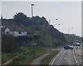
6
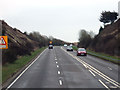
Buckle Bypass, Seaford.
The Buckle Bypass cuts through Hawth Hill and was opened in 1963 to avoid traffic having to negotiate Marine Parade which was often flooded during high tides.
Image: © Kevin Gordon
Taken: 1 Mar 2008
0.05 miles
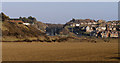
9
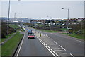
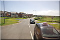
Hawth Park Road
Post war housing estate built on Hawth Hill.
Image: © Simon Carey
Taken: 15 Nov 2009
0.07 miles