IMAGES TAKEN NEAR TO
Edinburgh Road, SEAFORD, BN25 2PP
Introduction
This page details the photographs taken nearby to Edinburgh Road, BN25 2PP by members of the Geograph project.
The Geograph project started in 2005 with the aim of publishing, organising and preserving representative images for every square kilometre of Great Britain, Ireland and the Isle of Man.

There are currently over 7.5m images from over14,400 individuals and you can help contribute to the project by visiting https://www.geograph.org.uk
Image Map
Images are licensed for reuse under creativecommons.org/licenses/by-sa/2.0
Notes
- Clicking on the map will re-center to the selected point.
- The higher the marker number, the further away the image location is from the centre of the postcode.
Image Listing (103 Images Found)
Images are licensed for reuse under creativecommons.org/licenses/by-sa/2.0
Image
Details
Distance
1
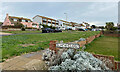
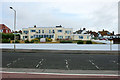
Edinburgh Road, Seaford, from Beach Close
A story of seaside development.
Image: © Robin Stott
Taken: 18 Oct 2021
0.00 miles
2
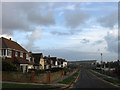
Park Road
Small cul-de-sac off Edinburgh Road that ends at Salts Recreation Ground. Seaford Head can be seen in the distance.
Image: © Simon Carey
Taken: 15 Nov 2009
0.05 miles
3
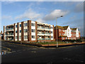
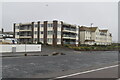
Marine Court
Block of flats on the corner of Marine Parade and Connaught Road that was built in the early 1980s. The block of flats on the right is Edinburgh Court.
Image: © Simon Carey
Taken: 15 Nov 2009
0.07 miles
4
Houses, Marine Parade
Located between the junction with Edinburgh Road and Salts Recreation Ground.
Image: © Simon Carey
Taken: 15 Nov 2009
0.07 miles
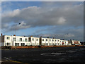
5
Beachlands Residential Care Home, Seaford
On Marine Parade, i.e. the seafront.
Image: © Robin Webster
Taken: 15 Jul 2010
0.07 miles
7
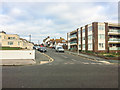
Connaught Road
Road off Esplanade. The block on the right is Marine Court.
Image: © Ian Capper
Taken: 1 Jan 2019
0.07 miles
8
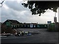
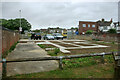
Lambes Bridge
Now a recycling centre and small car park for a nearby parade of shops but formerly the northern end of Edinburgh Road at its junction with Claremont Road. The former has been diverted to join the latter to the south of the railway.
Image: © Simon Carey
Taken: 15 Nov 2009
0.07 miles
9
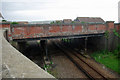
Railway bridge STS/812, Seaford
Viewed from bridge STS/811. The bridge has been disused as a road bridge for some years, and more recently had a domestic recycling station partly on it. This has now closed, as from 11/12/2009. The bridge now bears some raw earth and paving, which might become flowerbeds or lawn. It still acts as a pedestrian bridge, slightly more convenient in some directions than using bridge STS/811.
Image: © Robin Webster
Taken: 15 Jul 2010
0.08 miles
10
Railway bridge STS 812, Seaford
A curiosity, built later than the bridge on Claremont Road nearby, and much wider, it never seems to have been used as a road. It looks like it was intended to be a better and straighter north end to Edinburgh Road, so what happened?
Image: © Robin Webster
Taken: 15 Jul 2010
0.08 miles