IMAGES TAKEN NEAR TO
Blatchington Road, SEAFORD, BN25 2AF
Introduction
This page details the photographs taken nearby to Blatchington Road, BN25 2AF by members of the Geograph project.
The Geograph project started in 2005 with the aim of publishing, organising and preserving representative images for every square kilometre of Great Britain, Ireland and the Isle of Man.

There are currently over 7.5m images from over14,400 individuals and you can help contribute to the project by visiting https://www.geograph.org.uk
Image Map
Images are licensed for reuse under creativecommons.org/licenses/by-sa/2.0
Notes
- Clicking on the map will re-center to the selected point.
- The higher the marker number, the further away the image location is from the centre of the postcode.
Image Listing (288 Images Found)
Images are licensed for reuse under creativecommons.org/licenses/by-sa/2.0
Image
Details
Distance
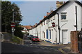
2
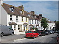
Blatchington Road & Broad Street junction
Image: © Oast House Archive
Taken: 21 Jun 2014
0.01 miles
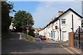
3
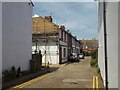
Terraced houses, west end of Blatchington Road, Seaford
Image: © Robin Stott
Taken: 5 May 2014
0.02 miles
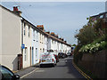
4
Footpath off Blatchington Road, Seaford
Image: © Robin Stott
Taken: 16 May 2021
0.02 miles
5
Richmond Terrace, off Blatchington Road, Seaford
Image: © Robin Stott
Taken: 5 May 2014
0.04 miles
6
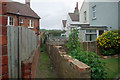
Back alley (narrow) Seaford
This appears to be a dead-end. The next street is substantially below this level. Reached via a wider alley - see Image .
Image: © Robin Webster
Taken: 15 Jul 2010
0.04 miles
8
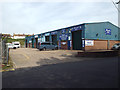
Small business units, Blatchington Road, Seaford
Apart from a tile centre, they are all offering car servicing, MOTs and hand car washing.
Image: © Robin Stott
Taken: 5 May 2014
0.05 miles
9
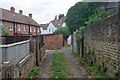
Back alley (wide) Seaford
This degenerates to pedestrian width around the corner, apparently with no egress. See Image
Image: © Robin Webster
Taken: 15 Jul 2010
0.06 miles
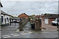
10
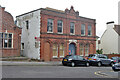
Drill Hall, Seaford, 2010
The red sign advises that it is the base of No. 2 Cadet Platoon, Sussex, Army Cadet Force. However, it does not look in much use, and was later converted to flats. It was built in 1898, called Queen's Hall, which name has been carried forward to the current flats.
Image: © Robin Webster
Taken: 15 Jul 2010
0.06 miles