IMAGES TAKEN NEAR TO
Blatchington Road, SEAFORD, BN25 2AA
Introduction
This page details the photographs taken nearby to Blatchington Road, BN25 2AA by members of the Geograph project.
The Geograph project started in 2005 with the aim of publishing, organising and preserving representative images for every square kilometre of Great Britain, Ireland and the Isle of Man.

There are currently over 7.5m images from over14,400 individuals and you can help contribute to the project by visiting https://www.geograph.org.uk
Image Map
Images are licensed for reuse under creativecommons.org/licenses/by-sa/2.0
Notes
- Clicking on the map will re-center to the selected point.
- The higher the marker number, the further away the image location is from the centre of the postcode.
Image Listing (315 Images Found)
Images are licensed for reuse under creativecommons.org/licenses/by-sa/2.0
Image
Details
Distance
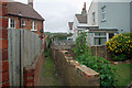
1
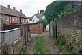
Back alley (wide) Seaford
This degenerates to pedestrian width around the corner, apparently with no egress. See Image
Image: © Robin Webster
Taken: 15 Jul 2010
0.02 miles
2
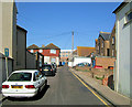
Clinton Lane, Seaford, East Sussex
This short road runs parallel to Clinton Place. The building at the end of the road is the old Caffyn's Garage. The building to the right of the telegraph pole with the orange roof is the Congregational Church Hall. (Now called the Crossway Centre)
Image: © Kevin Gordon
Taken: 25 Jun 2008
0.02 miles
3
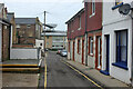
Clinton Lane, Seaford
The backs of shops on Clinton Place are on the left.
Image: © Robin Webster
Taken: 15 Jul 2010
0.02 miles
5
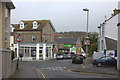
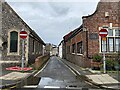
Blatchington Road, Seaford
Looking towards the junction with Claremont Road
Image: © Robert Eva
Taken: 14 Mar 2020
0.03 miles
6
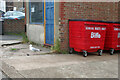
Bins and a Herring Gull, Seaford
Clinton Lane behind shops on Clinton Place.
Image: © Robin Webster
Taken: 15 Jul 2010
0.03 miles
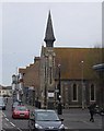
7
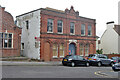
Drill Hall, Seaford, 2010
The red sign advises that it is the base of No. 2 Cadet Platoon, Sussex, Army Cadet Force. However, it does not look in much use, and was later converted to flats. It was built in 1898, called Queen's Hall, which name has been carried forward to the current flats.
Image: © Robin Webster
Taken: 15 Jul 2010
0.03 miles
8
Old Market Cottages
On the corner of Clinton Place and Broad Street.
Behind the Old Market Cottages is the former Drill Hall Image
The Drill Hall was originally the Queen's Hall and was built in 1898. The Territorial Army took it over in 1904. Between the wars it was used as a concert hall. During the Second World War the Home Guard used this building as their HQ. Cadets were still using the building in 2009 https://seafordcurrents.wordpress.com/2011/08/26/whats-happening-to-the-drill-hall-in-seaford/ It has since been converted into apartments.
Image: © Gerald England
Taken: 27 Apr 2017
0.03 miles
9
Back alley (narrow) Seaford
This appears to be a dead-end. The next street is substantially below this level. Reached via a wider alley - see Image .
Image: © Robin Webster
Taken: 15 Jul 2010
0.03 miles
10
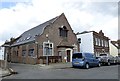
The Clinton Centre
A christian centre in the middle of Seaford.
Image: © N Chadwick
Taken: 29 Apr 2010
0.03 miles