IMAGES TAKEN NEAR TO
Steyne Road, SEAFORD, BN25 1HA
Introduction
This page details the photographs taken nearby to Steyne Road, BN25 1HA by members of the Geograph project.
The Geograph project started in 2005 with the aim of publishing, organising and preserving representative images for every square kilometre of Great Britain, Ireland and the Isle of Man.

There are currently over 7.5m images from over14,400 individuals and you can help contribute to the project by visiting https://www.geograph.org.uk
Image Map
Images are licensed for reuse under creativecommons.org/licenses/by-sa/2.0
Notes
- Clicking on the map will re-center to the selected point.
- The higher the marker number, the further away the image location is from the centre of the postcode.
Image Listing (387 Images Found)
Images are licensed for reuse under creativecommons.org/licenses/by-sa/2.0
Image
Details
Distance
2
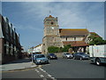
St Leonards Church, Seaford
The church dates from the early 11th century, although there have been many additions since that time. Brown patches on some of the stonework are burn marks; these are the results of attacks by the French during the Hundred Years War, which started in 1338.
http://www.roughwood.net/ChurchAlbum/EastSussex/Seaford/SeafordStLeonard2004.htm
Image: © Paul Gillett
Taken: 9 May 2009
0.02 miles
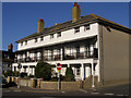
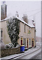
3
Parliament Row, Steyne Road, Seaford
A nice row of 18th century cottages. Prior to the Reform Act of 1832, Seaford was a 'Rotten Borough' Returning two Members of parliament even though there were few local people eligible to vote. This may be how the terrace gets its name.
Image: © Kevin Gordon
Taken: 15 Nov 2007
0.02 miles
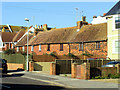
4
Chatham Place, Seaford
This small row of houses leads from Steyne Road to the West Street Car-Park. It is named after William Pitt the Elder (1708-1778) who was Prime Minister from 1766 to 1768. He was MP for Seaford from 1747 to 1754 and in 1766 was made the 1st Earl of Chatham.
Image: © Kevin Gordon
Taken: 26 Jun 2008
0.02 miles
5
The Wellington Pub from the High Street, Seaford, East Sussex
This pub was formerly called the "New Inn" but in 1845 the Duke of Wellington was believed to have stayed here whilst reviewing the Cinque Ports.
Image: © Kevin Gordon
Taken: 6 Apr 2008
0.02 miles
7
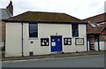
The Old Town Hall
The Old Town Hall served the old Borough of Seaford from the 1560s to the 1880s as Town Hall Court House and Gaol . Its appearance now is somewhat changed from earlier times. It was once described as having a diminutive outside stair case leading to a diminutive entrance door topped by a diminutive spire. Underneath it had a diminutive prison. A ground floor entrance led to the Town Hall, whilst the staircase led to the small court room. Today its is a used as a community tea room. http://www.seafordheritagetrails.co.uk/index.php/heritage/33-old-town-hall
Image: © Gerald England
Taken: 27 Apr 2017
0.03 miles
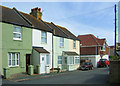
8
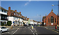
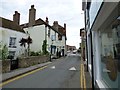
Steyne Road, Seaford
Showing Marine Terrace (left), the Wellington Public House and the former Methodist Church - now the Crossway Centre.
Image: © Kevin Gordon
Taken: 12 Jul 2007
0.03 miles
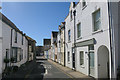
9
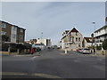
Junction of The Causeway and Steyne Road
Image: © Basher Eyre
Taken: 28 Feb 2016
0.03 miles
10
The Wellington
Originally known as the New Inn. Now a Greene King house.
Image
Image: © Gerald England
Taken: 27 Apr 2017
0.03 miles