IMAGES TAKEN NEAR TO
The Covers, SEAFORD, BN25 1DF
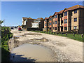
Introduction
This page details the photographs taken nearby to The Covers, BN25 1DF by members of the Geograph project.
The Geograph project started in 2005 with the aim of publishing, organising and preserving representative images for every square kilometre of Great Britain, Ireland and the Isle of Man.

There are currently over 7.5m images from over14,400 individuals and you can help contribute to the project by visiting https://www.geograph.org.uk
Image Map
Images are licensed for reuse under creativecommons.org/licenses/by-sa/2.0
Notes
- Clicking on the map will re-center to the selected point.
- The higher the marker number, the further away the image location is from the centre of the postcode.
Image Listing (212 Images Found)
Images are licensed for reuse under creativecommons.org/licenses/by-sa/2.0
Image
Details
Distance
1

Corner of Cricketfield Road and Marine Crescent, Seaford
Image: © Robin Stott
Taken: 25 Dec 2014
0.06 miles
2
Martello Road, Seaford
An unadopted section. The address of the flats, right, is The Boundary, a cul-de-sac off Ringmer Road at the back.
Image: © Robin Stott
Taken: 5 May 2018
0.07 miles
3

Junction of Cricketfield Road and College Road, Seaford
Beyond the seafront road are beach huts and the Martello tower, now a museum.
Image: © Robin Stott
Taken: 25 Dec 2014
0.07 miles
4
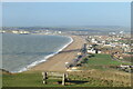
Seaford from the coastal path
The Vanguard Way ends its long journey from Croydon with a steep descent to Seaford. Newhaven in the distance.
Image: © David M Clark
Taken: 30 Nov 2018
0.08 miles
5

Open space behind and below the seafront, Seaford
Image: © Robin Stott
Taken: 25 Dec 2014
0.08 miles
6
Corsica Hall, Seaford
This fine building has recently been subject to extensive renovations and now contains a number of self-contained flats.
Image: © PAUL FARMER
Taken: 16 Jul 2009
0.09 miles

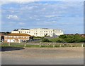
8
Seaford, Martello tower
Martello Tower No 74, overlooking Seaford Beach; built c 1810 in case of a Napoleonic invasion. The building now houses Seaford Museum. Grade II listed by Historic England: https://historicengland.org.uk/listing/the-list/list-entry/1017359
Image: © Mike Faherty
Taken: 11 May 2019
0.10 miles
9
Martello Tower and cliffs, Seaford
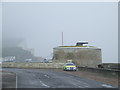
The circular building is a Martello Tower, one of a number of such towers along the coastline of South East England and East Anglia. The towers were built at the beginning of the 19th Century to defend England against invasion by the French, led by Napoleon. The tower now houses Seaford Museum. More information about the tower is available on Seaford Museum's website http://www.seafordmuseum.co.uk/the-tower.htm
Just visible in the background through the mist are chalk cliffs.
Image: © Malc McDonald
Taken: 17 Mar 2012
0.10 miles
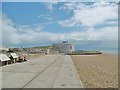
10
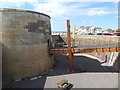
The Martello Tower at Seaford
Housing the town museum and approached by a bridge over the moat.
Image: © Oliver Dixon
Taken: 13 Sep 2019
0.10 miles