IMAGES TAKEN NEAR TO
Cliff Road, SEAFORD, BN25 1BH
Introduction
This page details the photographs taken nearby to Cliff Road, BN25 1BH by members of the Geograph project.
The Geograph project started in 2005 with the aim of publishing, organising and preserving representative images for every square kilometre of Great Britain, Ireland and the Isle of Man.

There are currently over 7.5m images from over14,400 individuals and you can help contribute to the project by visiting https://www.geograph.org.uk
Image Map
Images are licensed for reuse under creativecommons.org/licenses/by-sa/2.0
Notes
- Clicking on the map will re-center to the selected point.
- The higher the marker number, the further away the image location is from the centre of the postcode.
Image Listing (201 Images Found)
Images are licensed for reuse under creativecommons.org/licenses/by-sa/2.0
Image
Details
Distance
1
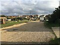
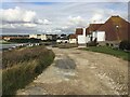
Cliff Road, Seaford
Cliff Road is an unmade road which links Corsica Road and Gerald Road. It is close to Seaford Head Golf Course. This is a view looking towards East Blatchington.
Image: © Kevin Gordon
Taken: 11 Feb 2009
0.04 miles
2
East on Gerald Road, Seaford
Gerald Road is one of a number of named but unmetalled roads in the southern corner of the town. Tamarisk in shadow on the right.
Image: © Robin Stott
Taken: 17 Oct 2020
0.04 miles
3
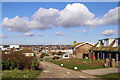
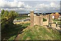
Flat-roofed houses, Cliff Close, Seaford
The view is from unmetalled Cliff Road. In the centre of the photo are the apartment blocks of the town centre; chalk cliffs beyond Newhaven catch the sun.
Image: © Robin Stott
Taken: 17 Oct 2020
0.04 miles
4
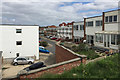
Cliff Close, Seaford
Seen from the public footpath up on to Seaford Head. Going by old maps, nearby Cliff Road, Corsica Road, Gerald Road and Maurice Road were shown laid out in 1910 but by 1927 were only partly developed with houses. Cliff Close was built between 1963 and 1974.
Image: © Robin Stott
Taken: 14 May 2016
0.05 miles
5
Detached gate pillars and wall, Gerald Road, Seaford
Beyond the wall is Gerald Road, turning right at the top of Cliff Road Image The flat roofs of Cliff Close houses can be seen to the left of the pillar. Old maps show that between 1899, before Cliff Road was developed, and 1950 there was a property on the cliff some way behind the camera, named on a 1927 map as Cliff Cottage. By 1963 it had gone; there was just a drive. There seems no reason to doubt that this was the entrance to the property. The location is now an informal piece of ground leading to a viewpoint and the lower slopes of Seaford Head.
Image: © Robin Stott
Taken: 17 Oct 2020
0.05 miles
6
Pillars and entrance drive to Cliff Cottage, Seaford, East Sussex
The view in the photo shows a former entrance drive with two brick pillars and an adjoining arch that led from Cliff Road to Cliff Cottage. These features were not present at the time of the original owner, Maria Fleming Baxter, during the early 1900’s but were added later, probably in the 1920’s. Although there was a plan to develop the site in the 1960s by building thirty garages in the area of the grassy drive, those plans did not materialize. Corsica Hall can be seen in direct line of sight through the entrance pillars.
Image: © Andrew Diack
Taken: 30 Mar 2024
0.05 miles
7
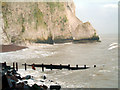
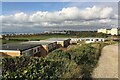
Seaford Head
The base of Seaford Head Cliff on a winter's day.
Image: © Michele Findlay
Taken: 12 Jan 2005
0.06 miles
8
Northwest and downhill on Cliff Road, Seaford
Cliff Road is one of a number of named roads locally, lined with substantial houses, but apparently unadopted by the highway authority, hence unmetalled. The cream-painted block of flats left of centre is referred to on a streetmap as The Lodge but by estate agents' websites as Corsica Hall.
Image: © Robin Stott
Taken: 17 Oct 2020
0.06 miles
9
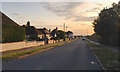
September evening, Corsica Road, Seaford
Image: © Robin Stott
Taken: 7 Sep 2019
0.06 miles
10
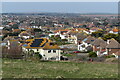
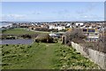
View over Seaford
The nearest houses are in Maurice Road.
Image: © David Martin
Taken: 21 Mar 2022
0.06 miles