IMAGES TAKEN NEAR TO
Egginton Road, BRIGHTON, BN2 4PL
Introduction
This page details the photographs taken nearby to Egginton Road, BN2 4PL by members of the Geograph project.
The Geograph project started in 2005 with the aim of publishing, organising and preserving representative images for every square kilometre of Great Britain, Ireland and the Isle of Man.

There are currently over 7.5m images from over14,400 individuals and you can help contribute to the project by visiting https://www.geograph.org.uk
Image Map
Images are licensed for reuse under creativecommons.org/licenses/by-sa/2.0
Notes
- Clicking on the map will re-center to the selected point.
- The higher the marker number, the further away the image location is from the centre of the postcode.
Image Listing (14 Images Found)
Images are licensed for reuse under creativecommons.org/licenses/by-sa/2.0
Image
Details
Distance
1
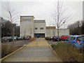
The Keep, Brighton
The Keep is a world-class centre for archives that opens up access to all the collections of the East Sussex Record Office (ESRO), the Royal Pavilion & Museums Local History Collections and the internationally significant University of Sussex Special Collections. It is also a centre of excellence for conservation and preservation and represents the new generation of archive buildings in the UK.
The combined collections have synergies and have been brought together to provide, under one roof, an unrivalled, detailed record of the region’s history, dating back over 900 years. These archives document the lives of individuals, places and events from across the county and beyond, and they include written records, maps and plans, prints and drawings, photographs and films, oral histories, and digital and electronic records http://www.thekeep.info/about_us/
Image: © Paul Gillett
Taken: 10 Mar 2016
0.07 miles
2
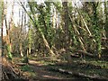
Westlain Belt
Small wood that lies to the south of the Brian Aldridge Community Academy.
Image: © Simon Carey
Taken: 9 Mar 2014
0.09 miles
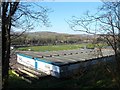
3
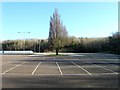
The Bridge Car Park
The car park is located on the old site of Falmer School which opened here in the 1950s and was known as Stanmer as well as Westlain in its time. The buildings were demolished three years ago after the school moved to a new build out of shot to the left. At the far end of the car park is Image and Image though this view will not remain for too long as planning permission has been given to build a combined student residence and multi-storey car park for the nearby football ground.
Image: © Simon Carey
Taken: 9 Mar 2014
0.12 miles
4
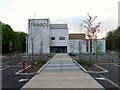
The Keep
The new record office for East Sussex was opened last November and also contains the Mass Observation archive that was previously held in the University of Sussex library and the Brighton History Centre which was previously located within the Brighton Museum in the centre of the city. The building lies on a strip of land called Woollards Field that is located between the railway and A270.
Image: © Simon Carey
Taken: 19 Apr 2014
0.12 miles
5
The Bridge Community Education Centre
Temporary building housing an adult community and education centre which was once located in the old Falmer School which occupied the site until its recent demolition. Richmond Hill is beyond containing the wood known as Russell's Clump.
Image: © Simon Carey
Taken: 9 Mar 2014
0.13 miles
6
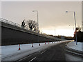
Lewes Road (A270)
The former route of the A27 that was redesignated in the 1990s when the new by-pass was built. It is currently getting another redevelopment as a new flyover is nearing opening which is designed to take traffic off the A27 onto the A270 without getting caught up with the traffic lights installed for the new entrance and exit from the University of Sussex. The flyover was due to be opened on the 13th December but has been put back due to snow. This part of the road is the current entrance onto the A27 and will be subject to traffic lights at this point.
Image: © Simon Carey
Taken: 18 Dec 2010
0.16 miles
7
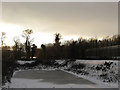
Balancing Pond
Squeezed between the railway and the A270. Balancing ponds are used to store excess run off and this one seems to be owned by the Highways Agency and was built in the 1990s at the same time as the new Brighton by-pass. Prior to that it was marked on maps as a playing field. Beyond the trees at the end of the pond is Wollards Field which will be the new site for the East Sussex Record Office to be known as The Keep.
Image: © Simon Carey
Taken: 18 Dec 2010
0.18 miles
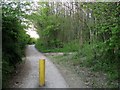
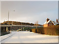
8

New Widened Access Road (1)
Originally a farm track that allowed access under the railway the lane was only as wide as the small bridge ahead. The track became an access point for the newly opened Stanmer County Secondary School (Later Falmer High School) which lay beyond the railway in the 1950s and remained so until this year when it was widened for a number of new developments; the rebuilding of the new Falmer Academy, the provision of a new car park for use by the school and the new football stadium, and the imminent construction of The Keep, a new records office for Brighton and East Sussex to replace the current cramped building in Lewes. The latter will be situated in what is now Wollards Field which lies to the west out of shot. Beyond the hedge on the left are the local offices for Southern Water built on the site of the former Falmer Pumping Station. See Image for a view from the railway end.
Image: © Simon Carey
Taken: 18 Dec 2010
0.18 miles
9
Surfaced Path, Coldean Belt
Laid in 2011 enabling access through the woods for cyclists and walkers to Stanmer Park, the universities and the football stadium though since the curtailing of parking in 2013 for outsiders that is mainly used only by supporters living in Coldean.
Image: © Simon Carey
Taken: 19 Apr 2014
0.18 miles
10
New Widened Access Road (2)
Opposite view to Image Originally a farm track then a narrow access lane to Stanmer Secondary School (Later renamed Falmer High School) now it has been widened as an access route for the imminent construction of a new East Sussex records office, the rebuilding of Falmer School and a new car park for both school and use for the new football stadium. The building on the corner is Pumping Station House built in 1904 for Falmer Pumping Station and the only survivor as the building housing the pumping equipment was demolished in 1967 and replaced with offices and depots currently occupied by Southern Water. Beyond that is the new flyover due to open last week but postponed due to the weather allowing those coming off the A27 onto the A270 to avoid the new traffic lights at the end of the new access road for the University of Sussex. Marquee Brow is the hill that provides the backdrop.
Image: © Simon Carey
Taken: 18 Dec 2010
0.20 miles