IMAGES TAKEN NEAR TO
Lewes Road, BRIGHTON, BN2 4GJ
Introduction
This page details the photographs taken nearby to Lewes Road, BN2 4GJ by members of the Geograph project.
The Geograph project started in 2005 with the aim of publishing, organising and preserving representative images for every square kilometre of Great Britain, Ireland and the Isle of Man.

There are currently over 7.5m images from over14,400 individuals and you can help contribute to the project by visiting https://www.geograph.org.uk
Image Map
Images are licensed for reuse under creativecommons.org/licenses/by-sa/2.0
Notes
- Clicking on the map will re-center to the selected point.
- The higher the marker number, the further away the image location is from the centre of the postcode.
Image Listing (32 Images Found)
Images are licensed for reuse under creativecommons.org/licenses/by-sa/2.0
Image
Details
Distance
1
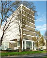
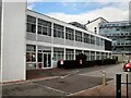
Cockcroft Building, University of Brighton
Image: © nick macneill
Taken: 5 Dec 2014
0.00 miles
2
Watts Building
Part of the University of Brighton Moulsecoomb Campus
Image: © Paul Gillett
Taken: 9 May 2009
0.05 miles
4
Cockcroft Building
Campus of the University of Brighton
Image: © Paul Gillett
Taken: 25 Oct 2009
0.06 miles
5
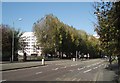
Trees by Lewes Road
Autumn colours on the trees beside the University of Brighton
Image: © Paul Gillett
Taken: 25 Oct 2009
0.08 miles
6
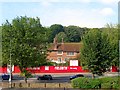
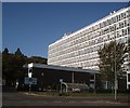
Preston Barracks, Lewes Road, Brighton
A view of the old officers mess which still stands at the northern end of the former barracks complex. Originally built in 1793 the barracks once occupied an extensive area to the south but these were sold in the late 1980s to become Image with former army housing sold to the council at the same time, see Image The Territorial Army occupied the remaining northern area until they left at the turn of the century. Since then the site has remained derelict. In 2014 the neighbouring University of Brighton announced it was going to take over the site and build new faculty buildings and student residences.
Image: © Simon Carey
Taken: 11 Oct 2015
0.10 miles
8
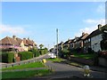
Southall Avenue, Moulescomb, Brighton
The southern tip of the estate that was built in the 1920s viewed from the junction with Natal Road. The road heads north to The Avenue.
Image: © Simon Carey
Taken: 11 Oct 2015
0.11 miles
9
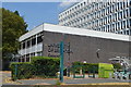
Cockcroft Library
Academic library at the University of Brighton
Image: © Paul Gillett
Taken: 15 Apr 2012
0.11 miles
10
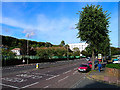
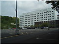
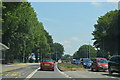
A270 Brighton
Looking north on the former A27 heading out of Brighton on the road to Lewes. The roof of the former Preston Barracks can be seen behind the trees. The barracks once owned extensive tracts of land in the area but have been sold off to become DIY superstores. The last remaining building is now for sale for major redevelopment leaving the white building to the left as the sole building associated with the military. It was given the name Preston Barracks due to it being in the parish rather than the vicinity of the village. The white building behind the former barracks is part of the University of Brighton.
Image: © Simon Carey
Taken: 9 Oct 2005
0.12 miles