1
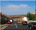
Coombe Road, Brighton
A view from the eastern end developed in the early 1920s near the junction with Bevendean Road. The road climbs Bear Hill and is a notorious rat run used by those wishing to avoid the Vogue Gyratory. The housing in the distance beyond the trees is the postwar part of Hollingdean.
Image: © Simon Carey
Taken: 11 Oct 2015
0.05 miles
2
New houses, Bevandean Road
Image: © Alex McGregor
Taken: 11 Feb 2013
0.05 miles
3
New houses, Bevendean Road
Image: © Alex McGregor
Taken: 11 Feb 2013
0.05 miles
4
House in Tenantry Road, Brighton
House at the junction of Tenantry Road and Fitzherbert Drive. The name 'Tenantry' comes from Tenantry Down and the area is in one of the former tenanted land divisions of Brighton known as 'laines'. 'Laine' was the local term for open arable fields common in medieval agriculture before enclosure.
Image: © Patrick Roper
Taken: 25 Aug 2010
0.09 miles
5
New housing on Bevendean Road
Looking at old Google images it appears that some of the houses in Baden Road, which back onto these new builds, have sold about half of their back gardens to accommodate.
Image: © Dave Spicer
Taken: 12 Aug 2012
0.09 miles
6
Playpark by Fitzherbert Drive
A children's play area in the Meadowview part of Brighton. Fitzherbert Drive is named after Mrs Fitzherbert who secretly married George IV when he was still Prince of Wales. She lived in Brighton for much of her life and is buried in Kemp Town.
Image: © Patrick Roper
Taken: 25 Aug 2010
0.10 miles
7
Amenity grass bank, Fitzherbert Drive
Some green open space on a modern (c. 2005) housing estate.
Image: © Patrick Roper
Taken: 25 Aug 2010
0.11 miles
8
Bear Rd
View west down Bear Rd. These houses are opposite some very large cemeteries. The road runs up Race Hill from the Lewes Rd , the A270, to where it meets Warren Road next to the racecourse on top of the downs.
Image: © Nigel Mykura
Taken: 13 Feb 2011
0.11 miles
9
Former Bevendean Hospital Gates, Bevendean Road, Brighton
The gates date from around 1900 and along with the two lodges that flank them are the only surviving parts of Bevendean Hospital. Built as an isolation hospital in 1881 during the outbreak of a smallpox epidemic the original buildings were wooden and thrown up quickly. By the 1890s they had come to the end of their working life and were subsequently replaced in 1898 by new stone buildings which included the gates. A further two wings were added between 1902-1905. It operated primarily as an isolation hospital until 1948 when it became part of the National Health Service though ironically it was isolated during part of 1951 following a local smallpox outbreak. The hospital's last years were spent mainly caring for psychiatric and geriatric patients and was closed to in-patients in April 1989 and for good in September 1990 after which the buildings were demolished.
See http://www.bygones.org.uk/images/uploaded/scaled/Bevendean_Hospital41.jpg for an aerial image of the hospital.
Image: © Simon Carey
Taken: 11 Oct 2015
0.12 miles
10
Fitzherbert Drive, Brighton
Built in the mid 1990s on southern end of the site once occupied by Bevendean Hospital. Viewed from the junction with Bevendean Road.
Image: © Simon Carey
Taken: 11 Oct 2015
0.12 miles


