IMAGES TAKEN NEAR TO
Popes Folly, BRIGHTON, BN2 4AN
Introduction
This page details the photographs taken nearby to Popes Folly, BN2 4AN by members of the Geograph project.
The Geograph project started in 2005 with the aim of publishing, organising and preserving representative images for every square kilometre of Great Britain, Ireland and the Isle of Man.

There are currently over 7.5m images from over14,400 individuals and you can help contribute to the project by visiting https://www.geograph.org.uk
Image Map
Images are licensed for reuse under creativecommons.org/licenses/by-sa/2.0
Notes
- Clicking on the map will re-center to the selected point.
- The higher the marker number, the further away the image location is from the centre of the postcode.
Image Listing (179 Images Found)
Images are licensed for reuse under creativecommons.org/licenses/by-sa/2.0
Image
Details
Distance
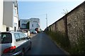
2
Popes Folly, BN2
See also Image (photographed by Simon Carey).
Image: © Mike Quinn
Taken: 25 Jun 2014
0.01 miles
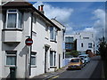
3
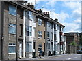
Pope's Folly, Brighton
Built around 1880 by a Mr Pope these properties are the only dwellings on the street and located at the junction with Image Beyond the road is used for access to a reservoir owned by Southern Water and as a path to Image To the east is Saunders Park.
Image: © Simon Carey
Taken: 11 Oct 2015
0.01 miles
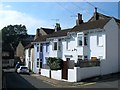
4
Popes Folly, Brighton
Popes Folly is a short and narrow street in Brighton.
Image: © Malc McDonald
Taken: 24 Aug 2019
0.01 miles
7
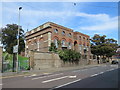
Former electricity substation, Hollingdean Road, Brighton
This building is shown on historic maps as an electricity substation. It appears to have been converted into apartments.
Image: © Malc McDonald
Taken: 24 Aug 2019
0.03 miles
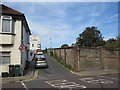
8
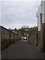
Popes Folly
Former access route for Preston Barracks from Hollingdean Road and providing the western boundary for Saunders Park. TQ3205 begins in the middle of the junction with Freehold Terrace next to the white van.
Image: © Simon Carey
Taken: 25 Dec 2008
0.03 miles
9
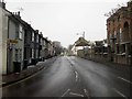
Hollingdean Road
Looking westwards from its junction with the Vogue Gyratory, the road links the A270 with Ditchling Road. Originally known as Dog Kennel Road in the early 19th century and ran in a straight line along what is now Image and Florence Place. Towards the end of the 19th century The area immediately north of the former was developed as a corporation depot and a new route, Upper Hollingdean Road was built to go round it. The building on the immediate right is a former electricity sub station built in 1924.
Image: © Simon Carey
Taken: 12 Mar 2013
0.03 miles
10
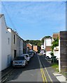
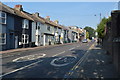
Freehold Terrace, Brighton
A residential road that runs between Pope's Folly and Hollingdean Road that was developed in the late 1860s. An old gas works used to be located at the western end.
Image: © Simon Carey
Taken: 11 Oct 2015
0.03 miles