IMAGES TAKEN NEAR TO
Maresfield Drive, PEVENSEY, BN24 6RX
Introduction
This page details the photographs taken nearby to Maresfield Drive, BN24 6RX by members of the Geograph project.
The Geograph project started in 2005 with the aim of publishing, organising and preserving representative images for every square kilometre of Great Britain, Ireland and the Isle of Man.

There are currently over 7.5m images from over14,400 individuals and you can help contribute to the project by visiting https://www.geograph.org.uk
Image Map
Images are licensed for reuse under creativecommons.org/licenses/by-sa/2.0
Notes
- Clicking on the map will re-center to the selected point.
- The higher the marker number, the further away the image location is from the centre of the postcode.
Image Listing (24 Images Found)
Images are licensed for reuse under creativecommons.org/licenses/by-sa/2.0
Image
Details
Distance
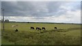
1
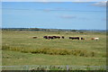
Red House Marsh
The name of the field according to the 1839 tithe map and part of Pevensey Bridge Level. Named after the now demolished Red House which was located opposite the entrance to Pebble Road.
Image: © Simon Carey
Taken: 14 Mar 2010
0.13 miles
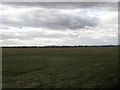
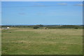
3
Lower Marsh
The name of the field according to the 1839 tithe map and part of Pevensey Bridge Level. The Beachlands estate part of the settlement of Pevensey Bay can be seen at the far end of the field.
Image: © Simon Carey
Taken: 6 Feb 2010
0.14 miles

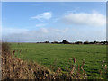
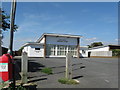
8
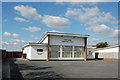
Ethel wood Community Centre, Pevensey Bay
Image: © Julian P Guffogg
Taken: 11 Apr 2010
0.17 miles
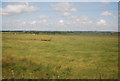
9
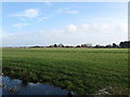
First Streaks
The name of the field according to the 1839 tithe map and part of Pevensey Bridge Level. The railway line lies at the end of the field with the Beachlands estate beyond.
Image: © Simon Carey
Taken: 6 Feb 2010
0.18 miles
10
Ethel Wood Community Centre Pevensey Bay
Image: © Dave Spicer
Taken: 20 Aug 2013
0.19 miles