IMAGES TAKEN NEAR TO
Normans Bay, PEVENSEY, BN24 6QN
Introduction
This page details the photographs taken nearby to BN24 6QN by members of the Geograph project.
The Geograph project started in 2005 with the aim of publishing, organising and preserving representative images for every square kilometre of Great Britain, Ireland and the Isle of Man.

There are currently over 7.5m images from over14,400 individuals and you can help contribute to the project by visiting https://www.geograph.org.uk
Image Map
Images are licensed for reuse under creativecommons.org/licenses/by-sa/2.0
Notes
- Clicking on the map will re-center to the selected point.
- The higher the marker number, the further away the image location is from the centre of the postcode.
Image Listing (39 Images Found)
Images are licensed for reuse under creativecommons.org/licenses/by-sa/2.0
Image
Details
Distance
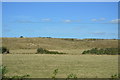
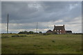
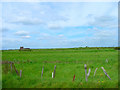
1
Rockhouse Bank
Looking towards Rockhouse Bank, with the Farm of the same name on its summit.
Image: © Chris McAuley
Taken: 22 Oct 2011
0.01 miles
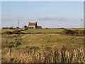
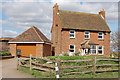
3
Rockhouse Bank Farm
Has a feeling of isolation being the only building on a small rise within the southern edge of Pevensey Levels though it does overlook buildings in nearby Normans Bay. There is no building marked on the Yeakell & Gardner map of 1778-83 though there is one on the first OS map of 1813 though the current structure is a relatively recent replacement.
Image: © Simon Carey
Taken: 6 Feb 2010
0.01 miles
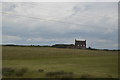
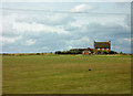
8
Rockhouse Bank
Site of a former gun emplacement erected during the Armada scare of 1857. It was still in use during the Napoleonic Wars complementing the batteries on Martello Towers 54 and 55. Rockhouse Bank Farm is to the left. Taken from the coast road connecting Pevensey and Norman's Bay.
Image: © Simon Carey
Taken: 28 May 2006
0.05 miles
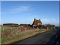
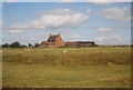
9
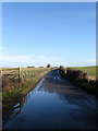
Sluice Lane
The old road across the marsh linking Pevensey to Bexhill and Hastings begins its climb up Rockhouse Bank towards the farm of the same name.
Image: © Simon Carey
Taken: 6 Feb 2010
0.10 miles