IMAGES TAKEN NEAR TO
Wallsend Road, PEVENSEY, BN24 6AA
Introduction
This page details the photographs taken nearby to Wallsend Road, BN24 6AA by members of the Geograph project.
The Geograph project started in 2005 with the aim of publishing, organising and preserving representative images for every square kilometre of Great Britain, Ireland and the Isle of Man.

There are currently over 7.5m images from over14,400 individuals and you can help contribute to the project by visiting https://www.geograph.org.uk
Image Map
Images are licensed for reuse under creativecommons.org/licenses/by-sa/2.0
Notes
- Clicking on the map will re-center to the selected point.
- The higher the marker number, the further away the image location is from the centre of the postcode.
Image Listing (44 Images Found)
Images are licensed for reuse under creativecommons.org/licenses/by-sa/2.0
Image
Details
Distance
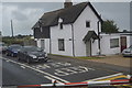
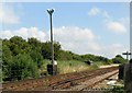
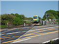
4
Pevensey Bay station
The Brighton, Lewes & Hastings Railway existed from February 1844 but only operated trains for a few weeks during June and July 1846 before it was amalgamated with other companies to form the London Brighton & South Coast Railway on 27th July 1846. Pevensey Bay station was opened by the London, Brighton & South Coast Railway on 11th September 1905, and was originally named Pevensey Bay Halt. It was renamed Pevensey Bay on 5th May 1969.
Most trains pass through and only five trains a day towards Hastings and three trains a day towards Eastbourne stop here. This view looks towards the level crossing to the east of the station at Wallsend Road.
Image: © Marathon
Taken: 5 Jun 2016
0.02 miles
6
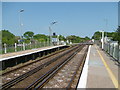
Pevensey Bay station
The Brighton, Lewes & Hastings Railway existed from February 1844 but only operated trains for a few weeks during June and July 1846 before it was amalgamated with other companies to form the London Brighton & South Coast Railway on 27th July 1846. Pevensey Bay station was opened by the London, Brighton & South Coast Railway on 11th September 1905, and was originally named Pevensey Bay Halt. It was renamed Pevensey Bay on 5th May 1969.
Most trains pass through and only five trains a day towards Hastings and three trains a day towards Eastbourne stop here. This view looks towards the level crossing to the east of the station at Wallsend Road.
Image: © Marathon
Taken: 5 Jun 2016
0.02 miles
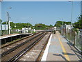
7
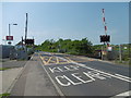
Level crossing on Wallsend Road
This is Wallsend Road on the way from Pevensey Bay to Pevensey. To the left of the crossing here is Pevensey Bay station.
The Brighton, Lewes & Hastings Railway existed from February 1844 but only operated trains for a few weeks during June and July 1846 before it was amalgamated with other companies to form the London Brighton & South Coast Railway on 27th July 1846. Pevensey Bay station was opened by the London, Brighton & South Coast Railway on 11th September 1905, and was originally named Pevensey Bay Halt. It was renamed Pevensey Bay on 5th May 1969.
Most trains pass through and only five trains a day towards Hastings and three trains a day towards Eastbourne stop here.
Image: © Marathon
Taken: 5 Jun 2016
0.02 miles
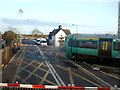
8
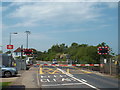
Pevensey Bay level crossing
The level crossing at Pevensey Bay railway station on the East Coastway line. The road forms part of the A259.
The lights are flashing and the barriers are down, indicating that a train is about to pass.
Image: © Malc McDonald
Taken: 26 May 2018
0.02 miles
9
A train approaching Pevensey Bay station
The Brighton, Lewes & Hastings Railway existed from February 1844 but only operated trains for a few weeks during June and July 1846 before it was amalgamated with other companies to form the London Brighton & South Coast Railway on 27th July 1846. Pevensey Bay station was opened by the London, Brighton & South Coast Railway on 11th September 1905, and was originally named Pevensey Bay Halt. It was renamed Pevensey Bay on 5th May 1969.
Most trains pass through and only five trains a day towards Hastings and three trains a day towards Eastbourne stop here. Here a Brighton-bound Southern train is about to cross Wallsend Road and pass through the station without stopping.
Image: © Marathon
Taken: 5 Jun 2016
0.02 miles
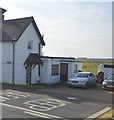
10
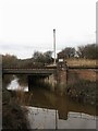
Salt Haven
The name of the waterway south of Pevensey Bridge which is known as Pevensey Haven to the north. This was an outlet to the sea until the mid 17th century when sluice gates were added near the beach which meant boats were no longer able to navigate the waterway. Today it is the main drain for the western side of Pevensey Levels. The bridge carries the East Coastway line over the waterway next to Wallsend level crossing which explains the presence of the CCTV camera.
Image: © Simon Carey
Taken: 24 Jan 2010
0.02 miles