IMAGES TAKEN NEAR TO
High Street, PEVENSEY, BN24 5LR
Introduction
This page details the photographs taken nearby to High Street, BN24 5LR by members of the Geograph project.
The Geograph project started in 2005 with the aim of publishing, organising and preserving representative images for every square kilometre of Great Britain, Ireland and the Isle of Man.

There are currently over 7.5m images from over14,400 individuals and you can help contribute to the project by visiting https://www.geograph.org.uk
Image Map
Images are licensed for reuse under creativecommons.org/licenses/by-sa/2.0
Notes
- Clicking on the map will re-center to the selected point.
- The higher the marker number, the further away the image location is from the centre of the postcode.
Image Listing (224 Images Found)
Images are licensed for reuse under creativecommons.org/licenses/by-sa/2.0
Image
Details
Distance
5
![Westham houses [9]](https://s1.geograph.org.uk/geophotos/07/21/64/7216409_14ea94ae_120x120.jpg)
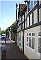
Westham houses [9]
Preston Cottage, number 74 High Street, was built in the early 19th century. Constructed of cobbles with brick dressings and quoins, now all painted, under a tile. Listed, grade II, with details at: https://historicengland.org.uk/listing/the-list/list-entry/1028495
The village of Westham is adjacent to the village of Pevensey some five miles (8 km) northeast of Eastbourne. The village is located on a spur of land that was a peninsula that projected into a tidal lagoon, now reclaimed marshland. The village is part of the Greater Eastbourne conurbation, and much recent expansion has taken place. Today it is a commuter village.
Image: © Michael Dibb
Taken: 4 May 2022
0.01 miles
6
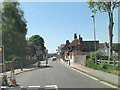
Westham High Street south of Church Avenue
Image: © Stuart Logan
Taken: 27 May 2012
0.01 miles
7
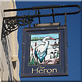
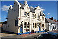
The Heron, Westham
The Heron pub in the village of Westham in East Sussex.
Image: © Malc McDonald
Taken: 26 May 2018
0.01 miles
8
![Westham buildings [2]](https://s2.geograph.org.uk/geophotos/07/21/64/7216414_e9370158_120x120.jpg)
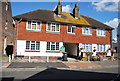
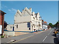
Westham buildings [2]
This range, number 33 High Street, was built in the 18th century. Constructed of stuccoed brick under a hipped tile roof. The nearer ground floor section, now used as offices, was formerly the Midland Bank. Listed, grade II, with details at: https://historicengland.org.uk/listing/the-list/list-entry/1028493
The village of Westham is adjacent to the village of Pevensey some five miles (8 km) northeast of Eastbourne. The village is located on a spur of land that was a peninsula that projected into a tidal lagoon, now reclaimed marshland. The village is part of the Greater Eastbourne conurbation, and much recent expansion has taken place. Today it is a commuter village.
Image: © Michael Dibb
Taken: 4 May 2022
0.01 miles
9
![Westham buildings [1]](https://s3.geograph.org.uk/geophotos/07/21/64/7216403_c9cd2bd0_120x120.jpg)
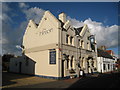
Westham buildings [1]
Numbers 76 and 76A High Street and Old George House, number 78 High Street (nearer the camera) were built in the 17th century or possibly earlier. The building has been refronted with stucco and imitation timer framing above. All under a tile roof. Listed, grade II, with details at: https://historicengland.org.uk/listing/the-list/list-entry/1353470
The village of Westham is adjacent to the village of Pevensey some five miles (8 km) northeast of Eastbourne. The village is located on a spur of land that was a peninsula that projected into a tidal lagoon, now reclaimed marshland. The village is part of the Greater Eastbourne conurbation, and much recent expansion has taken place. Today it is a commuter village.
Image: © Michael Dibb
Taken: 4 May 2022
0.02 miles