IMAGES TAKEN NEAR TO
Castle Road, PEVENSEY, BN24 5LG
Introduction
This page details the photographs taken nearby to Castle Road, BN24 5LG by members of the Geograph project.
The Geograph project started in 2005 with the aim of publishing, organising and preserving representative images for every square kilometre of Great Britain, Ireland and the Isle of Man.

There are currently over 7.5m images from over14,400 individuals and you can help contribute to the project by visiting https://www.geograph.org.uk
Image Map
Images are licensed for reuse under creativecommons.org/licenses/by-sa/2.0
Notes
- Clicking on the map will re-center to the selected point.
- The higher the marker number, the further away the image location is from the centre of the postcode.
Image Listing (372 Images Found)
Images are licensed for reuse under creativecommons.org/licenses/by-sa/2.0
Image
Details
Distance
1
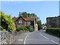
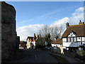
The Gables Pevensey
Albert Vidler, an accomplished architect, designed and built this house around 1880 in Castle Road (B2192)
Image: © PAUL FARMER
Taken: 16 Jul 2009
0.02 miles
2
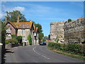
Priory Court Hotel Pevensey
The Priory Court Hotel is a 17th Century former vicarage that overlooks the ruins of Pevensey Castle. The road is the High Street (B2191)
Image: © PAUL FARMER
Taken: 16 Jul 2009
0.02 miles
4
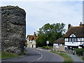
Castle Road, Pevensey
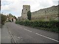
Now the B2191 until as recently as 2002 this was the main A259. This is the north eastern point of Pevensey Castle walls and gives an idea of just how much the castle imposes itself on the small village of Pevensey. This view looks east as Castle Road swings round and becomes Pevensey High Street.
Image: © Simon Carey
Taken: 21 Jan 2006
0.03 miles
6
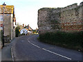
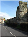
In the Shadow of the Castle
The outer walls of Pevensey Castle through a shadow over the Priory Court Hotel and The Gables. The former dates from the 17th century and was once the local vicarage whilst the latter dates from the late 19th century. The castle walls date back to the 4th century with medieval modifications. The road is the B2191 which hugs the northern walls of the castle and was the A27 until 1993.
Image: © Simon Carey
Taken: 20 Feb 2010
0.03 miles
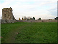
7
Part of the Pevensey Castle Walls
As from footpath inside the outer walls of the castle.
Image: © David Anstiss
Taken: 29 Dec 2016
0.04 miles
8
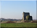
Bastion, Outer Walls, Pevensey Castle
Parts of the outer walls date from the 4th century and were built up and strengthened during the medieval period. This bastion was added in the early Tudor period and has modifications from World War Two where the former gaps were filled in and a machine gun post, which is just visible, was added to cover the levels. The house on the left is The Gables and dates from the late 19th century and the road is the B2191 which was the A27 up to 1993.
Image: © Simon Carey
Taken: 20 Feb 2010
0.04 miles
9
Pevensey Castle
Part of the Roman walls surrounding the outer bailey of Pevensey Castle.
Image: © Ian Capper
Taken: 15 Feb 2019
0.04 miles
10
Outer Walls, Pevensey Castle
Built on top of the original Roman walls around 1101. The chimneys beyond the wall belong to the Priory House Hotel and give some indication of size.
Image: © Simon Carey
Taken: 19 Feb 2008
0.04 miles