IMAGES TAKEN NEAR TO
High Street, PEVENSEY, BN24 5JP
Introduction
This page details the photographs taken nearby to High Street, BN24 5JP by members of the Geograph project.
The Geograph project started in 2005 with the aim of publishing, organising and preserving representative images for every square kilometre of Great Britain, Ireland and the Isle of Man.

There are currently over 7.5m images from over14,400 individuals and you can help contribute to the project by visiting https://www.geograph.org.uk
Image Map
Images are licensed for reuse under creativecommons.org/licenses/by-sa/2.0
Notes
- Clicking on the map will re-center to the selected point.
- The higher the marker number, the further away the image location is from the centre of the postcode.
Image Listing (333 Images Found)
Images are licensed for reuse under creativecommons.org/licenses/by-sa/2.0
Image
Details
Distance
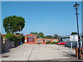
1
![Pevensey houses [2]](https://s1.geograph.org.uk/geophotos/07/21/43/7214393_bc31fb85_120x120.jpg)
Pevensey houses [2]
Camden Cottage, nearer the camera, and Post Office Cottage, in High Street, were built in 1717. Constructed of painted brick under a tile roof. Listed, grade II, with details at: https://historicengland.org.uk/listing/the-list/list-entry/1182622
Now a village, the former town of Pevensey is set some five miles (8 km) northeast of Eastbourne, and about one mile inland from Pevensey Bay where the Normans landed in 1066. The village is located on a spur of land that was a peninsula that projected into a tidal lagoon, now reclaimed marshland. In 1207 Pevensey was granted a royal charter and was governed by Pevensey Corporation which was dissolved in 1886 and the town lost its borough status.
Image: © Michael Dibb
Taken: 4 May 2022
0.00 miles
2
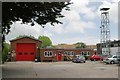
Pevensey fire station
Pevensey fire station, Lyons Close, Pevensey, East Sussex
Image: © Kevin Hale
Taken: 16 Jun 2007
0.02 miles
3
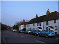
![Pevensey houses [3]](https://s2.geograph.org.uk/geophotos/07/21/43/7214394_e88b96fe_120x120.jpg)
Pevensey houses [3]
Lyons Close, High Street, was built in the 17th century. Constructed of red and grey brick under a tile roof. Listed, grade II, with details at: https://historicengland.org.uk/listing/the-list/list-entry/1043085
Now a village, the former town of Pevensey is set some five miles (8 km) northeast of Eastbourne, and about one mile inland from Pevensey Bay where the Normans landed in 1066. The village is located on a spur of land that was a peninsula that projected into a tidal lagoon, now reclaimed marshland. In 1207 Pevensey was granted a royal charter and was governed by Pevensey Corporation which was dissolved in 1886 and the town lost its borough status.
Image: © Michael Dibb
Taken: 4 May 2022
0.02 miles
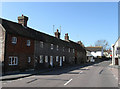
4
Cottages, High Street, Pevensey
The three to the right date from 1717 and include from left to right, Camden, Post Office and Candlewick Cottages respectively. The weatherboarded building beyond is one of Kings Cottages a small terrace at right angles to the road. The traffic light in the distance marks the junction of High Street with Wallsend Road.
Image: © Simon Carey
Taken: 6 Feb 2010
0.02 miles
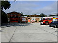
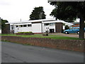
6
Pevensey community fire station
The community fire station in the village of Pevensey, in East Sussex.
Image: © Malc McDonald
Taken: 26 May 2018
0.04 miles
7
Penthouse Cottages, High Street, Pevensey
A row of four terraced houses dating possibly from the 18th century. The houses either end of the terrace have both had their original front doors bricked up.
Image: © Simon Carey
Taken: 17 Apr 2010
0.04 miles
8
![Pevensey houses [4]](https://s0.geograph.org.uk/geophotos/07/21/43/7214396_066252f9_120x120.jpg)
Pevensey houses [4]
Penthouse Cottages, numbers 1 to 4 High Street, are a row of 17th century, or possibly earlier, cottages. Timber framed, refaced in the 18th century. Three of the row are faced in cobbles with red brick dressings and stone quoins. One cottage has red brick to the ground floor and tile-hung above. All under a tile roof. Listed, grade II, with details at: https://historicengland.org.uk/listing/the-list/list-entry/1353409
Now a village, the former town of Pevensey is set some five miles (8 km) northeast of Eastbourne, and about one mile inland from Pevensey Bay where the Normans landed in 1066. The village is located on a spur of land that was a peninsula that projected into a tidal lagoon, now reclaimed marshland. In 1207 Pevensey was granted a royal charter and was governed by Pevensey Corporation which was dissolved in 1886 and the town lost its borough status.
Image: © Michael Dibb
Taken: 4 May 2022
0.04 miles
9
Pevensey Memorial Hall
This is the Village Hall in Pevensey. The smiley face on the side of the building is produced by what appears to be two air vents for eyes with the mouth being the seat of a bicycle which had been propped up there.
Image: © Terry Head
Taken: 9 Jun 2009
0.05 miles