IMAGES TAKEN NEAR TO
Banner Way, PEVENSEY, BN24 5FE
Introduction
This page details the photographs taken nearby to Banner Way, BN24 5FE by members of the Geograph project.
The Geograph project started in 2005 with the aim of publishing, organising and preserving representative images for every square kilometre of Great Britain, Ireland and the Isle of Man.

There are currently over 7.5m images from over14,400 individuals and you can help contribute to the project by visiting https://www.geograph.org.uk
Image Map
Images are licensed for reuse under creativecommons.org/licenses/by-sa/2.0
Notes
- Clicking on the map will re-center to the selected point.
- The higher the marker number, the further away the image location is from the centre of the postcode.
Image Listing (26 Images Found)
Images are licensed for reuse under creativecommons.org/licenses/by-sa/2.0
Image
Details
Distance
1
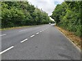
A27 near Eastbourne
This is the section of the A27 road, looking westbound, at Stone Cross, north of Eastbourne in East Sussex.
Image: © John P Reeves
Taken: 25 Jul 2022
0.10 miles
2
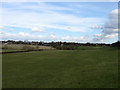
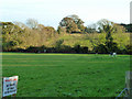
Barn Field (2)
The southern portion of Image part of which has been lost to the Pevensey By-Pass which lies beyond the bushes and down an embankment to the right. Saxon Nurseries are visible in the distance towards the centre.
Image: © Simon Carey
Taken: 20 Feb 2010
0.10 miles
3
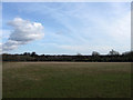
Lower Old Wells
The name of the field according to the 1838 tithe map. Viewed from the footpath that links Peelings Lane with Rattle Road with the western edge of Westham visible in the distance. Both that village and Stone Cross have expanded in the last thirty years and you wonder how long these green fields will remain.
Image: © Simon Carey
Taken: 20 Feb 2010
0.12 miles
4
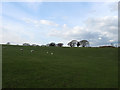
Nine Acres
The name of the field according to the 1838 tithe map. Part of the field now lies to the south of the Pevensey By-Pass with this section located to the west of Peelings.
Image: © Simon Carey
Taken: 20 Feb 2010
0.13 miles
5
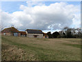
Private land
The field has a public footpath along its edge, confined between the hedge and a fence. It is adjacent to a housing estate.
Image: © Robin Webster
Taken: 17 Nov 2011
0.14 miles
6
Barn Field (1)
The name of the field according to the 1838 tithe map where the barns from Image back out onto the field. The field itself stretches southwards with part lost to the building of the Pevensey By-Pass in the early 1990s.
Image: © Simon Carey
Taken: 20 Feb 2010
0.14 miles
7
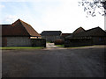
Peelings Manor Barns
A beautiful set of flint barns next to Peelings Manor. The barn in the foreground is occupied by JCJ Pottery which is open to the public, see http://www.jcjpottery.co.uk/ for more details.
Image: © Simon Carey
Taken: 20 Feb 2010
0.19 miles
9
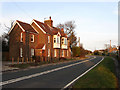
Rattle Road
Up until the early 1990s this was the A27 until the Pevensey By-Pass was built effectively relegating this road to a backwater used primarily for access to Stone Cross and Westham. The houses catching the late evening sun on the left are Woodville and Holly Cottage respectively. A local story explains that the name of the road was due to a nearby gallows in Westham where the unfortunate occupants' chains would rattle in the wind.
Image: © Simon Carey
Taken: 21 Mar 2010
0.20 miles
10
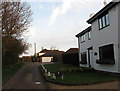
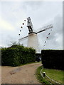
Beggars Lane
Private road that heads south east then doubles back again to Rattle Road near Uplands Farm. The building on the right is Mill House whilst part of the fantail and a sail of Stone Cross windmill can just be seen above it.
Image: © Simon Carey
Taken: 21 Mar 2010
0.20 miles