IMAGES TAKEN NEAR TO
Hankham Street, PEVENSEY, BN24 5BH
Introduction
This page details the photographs taken nearby to Hankham Street, BN24 5BH by members of the Geograph project.
The Geograph project started in 2005 with the aim of publishing, organising and preserving representative images for every square kilometre of Great Britain, Ireland and the Isle of Man.

There are currently over 7.5m images from over14,400 individuals and you can help contribute to the project by visiting https://www.geograph.org.uk
Image Map
Images are licensed for reuse under creativecommons.org/licenses/by-sa/2.0
Notes
- Clicking on the map will re-center to the selected point.
- The higher the marker number, the further away the image location is from the centre of the postcode.
Image Listing (38 Images Found)
Images are licensed for reuse under creativecommons.org/licenses/by-sa/2.0
Image
Details
Distance
2
National cycle route 2
Heading towards Rickney on a gentle descent onto the Pevensey Levels.
Image: © Robin Webster
Taken: 15 Nov 2011
0.02 miles
3
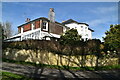
The Horns
The name of the white house on the left at the junction of lanes to the north of Hankham. Rickney Road is the lane in view.
Image: © Simon Carey
Taken: 21 Mar 2010
0.02 miles
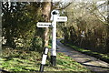
6
Direction Sign - Signpost north of Hankham
Black iron cap finial - 3 arms; East Sussex wood by the UC road, in parish of Westham (Wealden District), Hankham Street/Glynleigh Road junction, on grass island at intersection of Rickney Road with Hankham Street and Glynleigh Road.
Surveyed
Milestone Society National ID: SX_TQ6106
Image: © Milestone Society
Taken: Unknown
0.02 miles
7
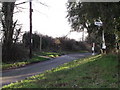
Junction of Glynleigh Road and Hankham Street, East Sussex
Image: © nick macneill
Taken: 20 Jan 2011
0.04 miles
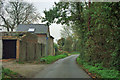
8
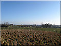
The Meadow
The name of the field according to the 1838 tithe map which has been subdivided into smaller plots. Broadlands Farm is to the left.
Image: © Simon Carey
Taken: 20 Feb 2010
0.05 miles
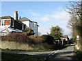
9
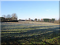
House Field
The name of the field according to the 1838 tithe map. The field was once much larger but has lost pieces to houses and their gardens as well as being subdivided into smaller plots. The two houses in the distance are Old Acre and Silverdale.
Image: © Simon Carey
Taken: 20 Feb 2010
0.05 miles
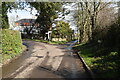
10
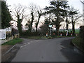
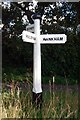
Junction of Hankham Street and Glynleigh Road
Looking east from Glynleigh Road. Left to Rickney, right to Hankham.
Image: © Simon Carey
Taken: 21 Jan 2006
0.05 miles