IMAGES TAKEN NEAR TO
Hankham Street, PEVENSEY, BN24 5BG
Introduction
This page details the photographs taken nearby to Hankham Street, BN24 5BG by members of the Geograph project.
The Geograph project started in 2005 with the aim of publishing, organising and preserving representative images for every square kilometre of Great Britain, Ireland and the Isle of Man.

There are currently over 7.5m images from over14,400 individuals and you can help contribute to the project by visiting https://www.geograph.org.uk
Image Map
Images are licensed for reuse under creativecommons.org/licenses/by-sa/2.0
Notes
- Clicking on the map will re-center to the selected point.
- The higher the marker number, the further away the image location is from the centre of the postcode.
Image Listing (51 Images Found)
Images are licensed for reuse under creativecommons.org/licenses/by-sa/2.0
Image
Details
Distance
1
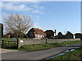
Hankham Barn
Converted flint barn at the northern edge of the hamlet.
Image: © Simon Carey
Taken: 21 Mar 2010
0.02 miles
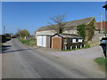
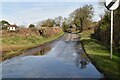
4
Hankham Street
Main street of the hamlet of Hankham heading north towards the junction next to The Horns. The buildings on the right are part of Hankham Barn.
Image: © Simon Carey
Taken: 20 Feb 2010
0.03 miles
5
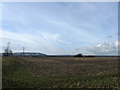
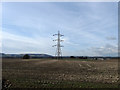
Barn Field
The name of this section of the field according to the 1838 tithe map which has been expanded to include Barley Piece, Lower and Upper Hales to the north and an unnamed area to the west. The South Downs are in the distance with Folkington Hill on the left and Wilmington Hill to the right.
Image: © Simon Carey
Taken: 20 Feb 2010
0.06 miles
6
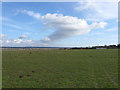
Upper Croft
The name of the field according to the 1838 tithe map. Pevensey Levels can be seen to the left with the higher ground of the Weald on the horizon.
Image: © Simon Carey
Taken: 20 Feb 2010
0.07 miles
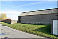
8
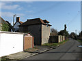
Pear Tree Cottage
On Hankham Street towards the northern edge of the hamlet. The shape seems to suggest a conversion from a former farm building.
Image: © Simon Carey
Taken: 21 Mar 2010
0.08 miles
9
Lower Hales
The name of this section of the field according to the 1838 tithe map which has been expanded to include Upper Hales to the north, Barley Piece and Barn Field to the south and an unnamed area to the west. The South Downs provide the backdrop.
Image: © Simon Carey
Taken: 20 Feb 2010
0.08 miles
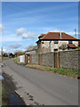
10
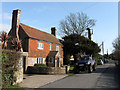
The Cottage
Old 18th century cottage on Hankham Street.
Image: © Simon Carey
Taken: 21 Mar 2010
0.10 miles