IMAGES TAKEN NEAR TO
Foords Lane, PEVENSEY, BN24 5AN
Introduction
This page details the photographs taken nearby to Foords Lane, BN24 5AN by members of the Geograph project.
The Geograph project started in 2005 with the aim of publishing, organising and preserving representative images for every square kilometre of Great Britain, Ireland and the Isle of Man.

There are currently over 7.5m images from over14,400 individuals and you can help contribute to the project by visiting https://www.geograph.org.uk
Image Map
Images are licensed for reuse under creativecommons.org/licenses/by-sa/2.0
Notes
- Clicking on the map will re-center to the selected point.
- The higher the marker number, the further away the image location is from the centre of the postcode.
Image Listing (38 Images Found)
Images are licensed for reuse under creativecommons.org/licenses/by-sa/2.0
Image
Details
Distance
1
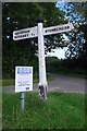
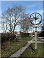
Old Direction Sign - Signpost by Hankham Road, Westham Parish
Black iron cap finial - 2 arms; East Sussex wood by the UC road, in parish of Westham (Wealden District), Hankham Road, on grass island at junction of Foords Lane with Hankham Road.
Surveyed
Milestone Society National ID: SX_TQ6105A
Image: © Milestone Society
Taken: Unknown
0.02 miles
2
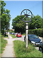
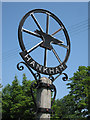
Hankham Village Sign
An anvil on a wheel. On Hankham Road, near the primary school.
Image: © Oast House Archive
Taken: 26 Jun 2010
0.09 miles
3
Hankham Village Sign
An anvil on a wheel. On Hankham Road, near the primary school.
Image: © Oast House Archive
Taken: 26 Jun 2010
0.09 miles
4
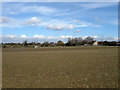
Twelve Acres
The name of the field according to the 1838 tithe map and located between the school whose grounds are at the far end of the field and Milton Street. The field itself has been expanded to include Clover Field to the west.
Image: © Simon Carey
Taken: 20 Feb 2010
0.10 miles
5
Hankham Village Sign
At the southern end of the hamlet near the primary school. The wheel and anvil represent the once local trades that operated here.
Image: © Simon Carey
Taken: 20 Feb 2010
0.12 miles
6
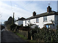
Victoria Cottages
Located on Milton Street a small lane that runs south from Hankham Road to Hailsham Road, the B2104. The 1910 OS map has the current name down for the cottages whilst the 1899 one has them as Hunt's Cottages. The bigger building beyond is Victoria Villa.
Image: © Simon Carey
Taken: 20 Feb 2010
0.14 miles
7
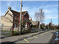
Hankham Primary School
Established in 1879 and still going strong today. In the picture is the original schoolmaster's house which is now part of the school, and the hall. Modern extensions have been added to the rear.
Image: © Simon Carey
Taken: 20 Feb 2010
0.14 miles
8
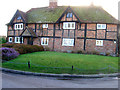
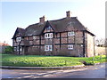
The Dog House, Hankham
This stands on the corner of Hankham Street and Hankham Hall Road. Built in the 1600s as three cottages it has been owned by Customs and Excise which is where the name is believed to have come from and the army during World War Two. It was converted into one residence early last century.
Image: © Simon Carey
Taken: 21 Jan 2006
0.14 miles
9
The Dog House, Hankham Road, Hankham, East Sussex
Grade II listed.
Image: © Oast House Archive
Taken: 14 Feb 2009
0.16 miles
10
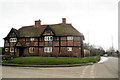
Beamed brick house, Hankham, East Sussex
Image: © nick macneill
Taken: 18 Jan 2011
0.16 miles