IMAGES TAKEN NEAR TO
Slindon Crescent, EASTBOURNE, BN23 7AZ
Introduction
This page details the photographs taken nearby to Slindon Crescent, BN23 7AZ by members of the Geograph project.
The Geograph project started in 2005 with the aim of publishing, organising and preserving representative images for every square kilometre of Great Britain, Ireland and the Isle of Man.

There are currently over 7.5m images from over14,400 individuals and you can help contribute to the project by visiting https://www.geograph.org.uk
Image Map
Images are licensed for reuse under creativecommons.org/licenses/by-sa/2.0
Notes
- Clicking on the map will re-center to the selected point.
- The higher the marker number, the further away the image location is from the centre of the postcode.
Image Listing (52 Images Found)
Images are licensed for reuse under creativecommons.org/licenses/by-sa/2.0
Image
Details
Distance
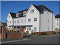
3
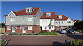
New housing off Pevensey Bay Road
Render and fibre cement clad houses, built 2013.
Image: © Oast House Archive
Taken: 28 Apr 2015
0.09 miles
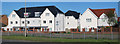
4
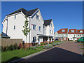
New housing off Pevensey Bay Road
Render and fibre cement clad houses, built 2013.
Image: © Oast House Archive
Taken: 28 Apr 2015
0.10 miles
5
New housing off Pevensey Bay Road
Render and fibre cement clad houses, built 2013.
Image: © Oast House Archive
Taken: 28 Apr 2015
0.10 miles
6

New housing off Pevensey Bay Road
Render and fibre cement clad houses, built 2013.
Image: © Oast House Archive
Taken: 28 Apr 2015
0.10 miles
7
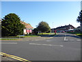
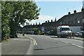
The setting of St Richard's Church, Langney
St Richard's Church at Langney dates from the 1950s. The church was extended in the 1970s, the 1980s and the 1990s. The parish dates from 1969. More about its history can be found at http://sussexparishchurches.org/product/eastbourne-st-richard-langney/ and http://discovery.nationalarchives.gov.uk/details/r/5b21adc9-edbc-464f-96ac-c5a00f1c504d
This view looks along Priory Road at the junction with Etchingham Road which is to the left here.
Image: © Marathon
Taken: 21 Oct 2018
0.11 miles
8
New housing off Pevensey Bay Road
Render and fibre cement clad houses, built 2013.
Image: © Oast House Archive
Taken: 28 Apr 2015
0.11 miles
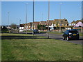
10
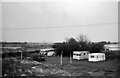
Near Pevensey ? 1966
The view was taken, from a passing bus, to include the old bus, which has remained unidentified (except that it is a Dennis chassis).
The main interest in the view is that it shows this section of the coast before the enormous Sovereign Harbour development arrived. The Martello Tower visible in the distance is No.65 at TQ 6470 0217.
Image: © Alan Murray-Rust
Taken: 11 Sep 1966
0.12 miles