IMAGES TAKEN NEAR TO
Barbuda Quay, EASTBOURNE, BN23 5TT
Introduction
This page details the photographs taken nearby to Barbuda Quay, BN23 5TT by members of the Geograph project.
The Geograph project started in 2005 with the aim of publishing, organising and preserving representative images for every square kilometre of Great Britain, Ireland and the Isle of Man.

There are currently over 7.5m images from over14,400 individuals and you can help contribute to the project by visiting https://www.geograph.org.uk
Image Map
Images are licensed for reuse under creativecommons.org/licenses/by-sa/2.0
Notes
- Clicking on the map will re-center to the selected point.
- The higher the marker number, the further away the image location is from the centre of the postcode.
Image Listing (234 Images Found)
Images are licensed for reuse under creativecommons.org/licenses/by-sa/2.0
Image
Details
Distance
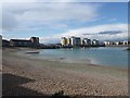
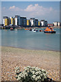
1
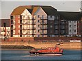
Apartments on Bermuda Place
Looking across the lifeboat at outer harbour.
Image: © Oast House Archive
Taken: 5 Dec 2011
0.04 miles
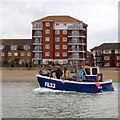
8
RNLB Diamond Jubilee arrives at Sovereign Harbour
Image: © Oast House Archive
Taken: 29 May 2012
0.07 miles
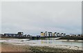
9

Sovereign Harbour
This was taken on the Sussex Coastline Walk.
Image: © Shazz
Taken: 24 Dec 2005
0.07 miles