IMAGES TAKEN NEAR TO
St. Lawrence Way, EASTBOURNE, BN23 5QE
Introduction
This page details the photographs taken nearby to St. Lawrence Way, BN23 5QE by members of the Geograph project.
The Geograph project started in 2005 with the aim of publishing, organising and preserving representative images for every square kilometre of Great Britain, Ireland and the Isle of Man.

There are currently over 7.5m images from over14,400 individuals and you can help contribute to the project by visiting https://www.geograph.org.uk
Image Map
Images are licensed for reuse under creativecommons.org/licenses/by-sa/2.0
Notes
- Clicking on the map will re-center to the selected point.
- The higher the marker number, the further away the image location is from the centre of the postcode.
Image Listing (111 Images Found)
Images are licensed for reuse under creativecommons.org/licenses/by-sa/2.0
Image
Details
Distance
3
Houses on Wellington Grove
Some curious 'vernacular' style modern houses, looking quite out of place adjacent the marina.
Image: © Oast House Archive
Taken: 30 May 2010
0.06 miles
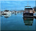
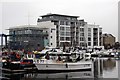
7
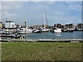
Sovereign Harbour Marina (North), Eastbourne
Large marina in the northern outskirts of Eastbourne.
Image: © G Laird
Taken: 20 Sep 2018
0.10 miles
9
Sovereign Harbour Yacht Club in Eastbourne
Image: © Steve Daniels
Taken: 18 May 2012
0.10 miles
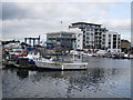
10
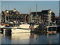
Catamaran Fishing Boats, Sovereign Harbour
Many fishing vessels are within the marina.
Including these two registered to Newhaven.
Image: © David Anstiss
Taken: 29 Dec 2016
0.11 miles