IMAGES TAKEN NEAR TO
Long Beach Mews, EASTBOURNE, BN23 5NF
Introduction
This page details the photographs taken nearby to Long Beach Mews, BN23 5NF by members of the Geograph project.
The Geograph project started in 2005 with the aim of publishing, organising and preserving representative images for every square kilometre of Great Britain, Ireland and the Isle of Man.

There are currently over 7.5m images from over14,400 individuals and you can help contribute to the project by visiting https://www.geograph.org.uk
Image Map
Images are licensed for reuse under creativecommons.org/licenses/by-sa/2.0
Notes
- Clicking on the map will re-center to the selected point.
- The higher the marker number, the further away the image location is from the centre of the postcode.
Image Listing (48 Images Found)
Images are licensed for reuse under creativecommons.org/licenses/by-sa/2.0
Image
Details
Distance
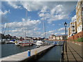
1
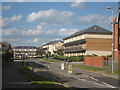
Pacific Drive
A large sprawl of houses built in the 2000s.
Image: © Oast House Archive
Taken: 30 May 2010
0.01 miles
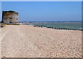
3
Sea front development, the Crumbles
A large apron of vegetated shingle has been spared on the left, a fragment of the very large area that has been built over. A Martello tower is on the left, one of several along this coast.
Image: © Robin Webster
Taken: 15 Nov 2011
0.08 miles

7
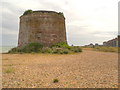
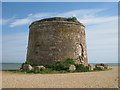
Martello Tower, Eastbourne
The martello tower to the north of Sovereign Harbour.
Image: © David Dixon
Taken: 4 Aug 2012
0.09 miles
8
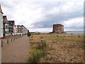
Martello Tower at Sovereign Harbour
Image: © Raymond Knapman
Taken: 10 Jul 2009
0.09 miles
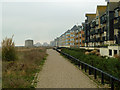
9
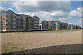
Seaside Apartments & Beach
Large rows of apartments built in the 2000s.
See more sizes for wider panorama.
Image: © Oast House Archive
Taken: 30 May 2010
0.10 miles