IMAGES TAKEN NEAR TO
Midway Quay, EASTBOURNE, BN23 5DB
Introduction
This page details the photographs taken nearby to Midway Quay, BN23 5DB by members of the Geograph project.
The Geograph project started in 2005 with the aim of publishing, organising and preserving representative images for every square kilometre of Great Britain, Ireland and the Isle of Man.

There are currently over 7.5m images from over14,400 individuals and you can help contribute to the project by visiting https://www.geograph.org.uk
Image Map
Images are licensed for reuse under creativecommons.org/licenses/by-sa/2.0
Notes
- Clicking on the map will re-center to the selected point.
- The higher the marker number, the further away the image location is from the centre of the postcode.
Image Listing (267 Images Found)
Images are licensed for reuse under creativecommons.org/licenses/by-sa/2.0
Image
Details
Distance
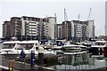
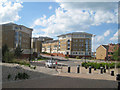
1

Modern Apartment Blocks at Sovereign Harbour
Image: © Oast House Archive
Taken: 3 Jul 2009
0.01 miles
3
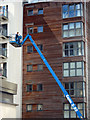
Maintenance at Victoria Quay apartments
Extendable lift by apartment buildings near the inner marina.
Image: © Oast House Archive
Taken: 25 Jul 2011
0.02 miles
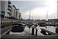
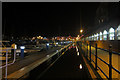
6
Pacific Drive
Looking to a roundabout at the end of Pacific Drive.
Image: © Oast House Archive
Taken: 25 Jul 2011
0.03 miles
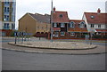
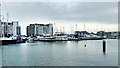
9
Apartments on Pacific Drive
The roundabout is the end of the road, and is private access further on.
Image: © Oast House Archive
Taken: 30 May 2010
0.05 miles