IMAGES TAKEN NEAR TO
Arequipa Reef, EASTBOURNE, BN23 5AG
Introduction
This page details the photographs taken nearby to Arequipa Reef, BN23 5AG by members of the Geograph project.
The Geograph project started in 2005 with the aim of publishing, organising and preserving representative images for every square kilometre of Great Britain, Ireland and the Isle of Man.

There are currently over 7.5m images from over14,400 individuals and you can help contribute to the project by visiting https://www.geograph.org.uk
Image Map
Images are licensed for reuse under creativecommons.org/licenses/by-sa/2.0
Notes
- Clicking on the map will re-center to the selected point.
- The higher the marker number, the further away the image location is from the centre of the postcode.
Image Listing (145 Images Found)
Images are licensed for reuse under creativecommons.org/licenses/by-sa/2.0
Image
Details
Distance
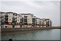
1
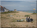
Beach by Sovereign Harbour
Looking towards Image
Image: © Oast House Archive
Taken: 25 Jul 2011
0.05 miles

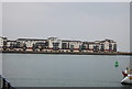
3
Macquarie Quay
Looking through an undercroft beneath apartments overlooking the outer harbour.
Image: © Oast House Archive
Taken: 25 Jul 2011
0.06 miles
4
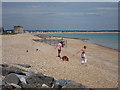
Beach by Sovereign Harbour
Looking towards Pevensey Bay
Image: © Oast House Archive
Taken: 25 Jul 2011
0.06 miles
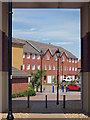
5
Macquarie Quay
Residential road at Sovereign Harbour.
Image: © Oast House Archive
Taken: 25 Jul 2011
0.07 miles
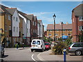
7
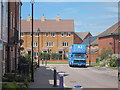
Removals at Macquarie Quay
Removals lorry at start of the residential road.
Image: © Oast House Archive
Taken: 25 Jul 2011
0.08 miles
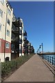
10
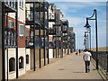
Promenade around outer harbour
Path to the beach. Apartments on Macquarie Quay to the left.
Image: © Oast House Archive
Taken: 25 Jul 2011
0.09 miles