IMAGES TAKEN NEAR TO
Percival Road, EASTBOURNE, BN22 9JS
Introduction
This page details the photographs taken nearby to Percival Road, BN22 9JS by members of the Geograph project.
The Geograph project started in 2005 with the aim of publishing, organising and preserving representative images for every square kilometre of Great Britain, Ireland and the Isle of Man.

There are currently over 7.5m images from over14,400 individuals and you can help contribute to the project by visiting https://www.geograph.org.uk
Image Map
Images are licensed for reuse under creativecommons.org/licenses/by-sa/2.0
Notes
- Clicking on the map will re-center to the selected point.
- The higher the marker number, the further away the image location is from the centre of the postcode.
Image Listing (16 Images Found)
Images are licensed for reuse under creativecommons.org/licenses/by-sa/2.0
Image
Details
Distance
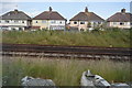
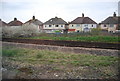
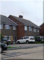
4
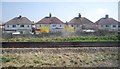
Houses on Percival Rd
The photo is taken where the two branches of the coastway line separate, north of Eastbourne.
Image: © N Chadwick
Taken: 12 Apr 2010
0.11 miles
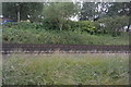
5
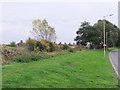
Grass verge on Huggets Lane, Eastbourne
The fence on the left runs alongside the Brighton to Eastbourne railway.
Image: © nick macneill
Taken: 29 Oct 2010
0.12 miles
6
Unusual tiling, Wilton Avenue, Eastbourne
Image: © nick macneill
Taken: 27 Jun 2012
0.13 miles

8
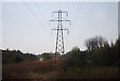
Pylon, Shinewater Park
http://www.eastbourne.gov.uk/leisure/parks/parks/shinewater-park/
Image: © N Chadwick
Taken: 24 Apr 2010
0.17 miles
9

Pond beside Cuckoo Trail
Near Hampden Park
Image: © Paul Gillett
Taken: 14 Jan 2019
0.18 miles
10
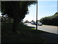
Hazlewood Avenue near its junction with Brodrick Road
Image: © Dave Spicer
Taken: 20 Aug 2013
0.19 miles