IMAGES TAKEN NEAR TO
Otham Road, EASTBOURNE, BN22 9HH
Introduction
This page details the photographs taken nearby to Otham Road, BN22 9HH by members of the Geograph project.
The Geograph project started in 2005 with the aim of publishing, organising and preserving representative images for every square kilometre of Great Britain, Ireland and the Isle of Man.

There are currently over 7.5m images from over14,400 individuals and you can help contribute to the project by visiting https://www.geograph.org.uk
Image Map
Images are licensed for reuse under creativecommons.org/licenses/by-sa/2.0
Notes
- Clicking on the map will re-center to the selected point.
- The higher the marker number, the further away the image location is from the centre of the postcode.
Image Listing (8 Images Found)
Images are licensed for reuse under creativecommons.org/licenses/by-sa/2.0
Image
Details
Distance
1
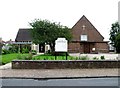
St. Peter's, The Hydneye, Eastbourne
The church was built in 1953.
Image: © nick macneill
Taken: 27 Jun 2012
0.19 miles
4
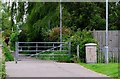
Cycleway, Fletching Road, Eastbourne
The passage is a cycleway towards Langney.
Image: © nick macneill
Taken: 27 Jun 2012
0.21 miles

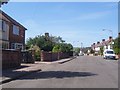
6
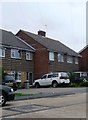
Unusual tiling, Wilton Avenue, Eastbourne
Image: © nick macneill
Taken: 27 Jun 2012
0.23 miles
7
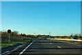
A22 heading out of Eastbourne
The local authority boundary is ahead on the rise where the road crosses the railway.
Image: © Robin Webster
Taken: 17 Nov 2011
0.23 miles
