IMAGES TAKEN NEAR TO
Manor Road, EASTBOURNE, BN22 9DS
Introduction
This page details the photographs taken nearby to Manor Road, BN22 9DS by members of the Geograph project.
The Geograph project started in 2005 with the aim of publishing, organising and preserving representative images for every square kilometre of Great Britain, Ireland and the Isle of Man.

There are currently over 7.5m images from over14,400 individuals and you can help contribute to the project by visiting https://www.geograph.org.uk
Image Map
Images are licensed for reuse under creativecommons.org/licenses/by-sa/2.0
Notes
- Clicking on the map will re-center to the selected point.
- The higher the marker number, the further away the image location is from the centre of the postcode.
Image Listing (9 Images Found)
Images are licensed for reuse under creativecommons.org/licenses/by-sa/2.0
Image
Details
Distance
1
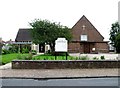
St. Peter's, The Hydneye, Eastbourne
The church was built in 1953.
Image: © nick macneill
Taken: 27 Jun 2012
0.08 miles

3
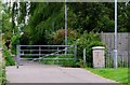
Cycleway, Fletching Road, Eastbourne
The passage is a cycleway towards Langney.
Image: © nick macneill
Taken: 27 Jun 2012
0.15 miles
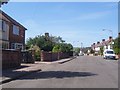
5

Ashington Road, Hampden Park, Eastbourne
Image: © nick macneill
Taken: 27 Jun 2012
0.20 miles


8

Bannatyne's Health Club, Edward Road, Eastbourne
Image: © PAUL FARMER
Taken: 21 Feb 2010
0.22 miles
9
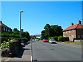
The Hydneye, Hampden Park, Eastbourne
The strangely named road commemorates the lost medieval village of Hydneye whose site is just behind the photographer to the north. Hydneye was important enough to be a minor member of the Cinque Ports. However, decay set in in the Thirteenth century as longshore drift silted up the entrance to the small harbour. The village depopulated further after the black death and soon disappeared altogether. The site is still marked on the 1870s map but is now built over by the suburb of Hampden Park, this part being built during the inter-war period. The sea is now three miles away.
Image: © Simon Carey
Taken: 16 Jul 2006
0.24 miles