IMAGES TAKEN NEAR TO
Brampton Road, EASTBOURNE, BN22 9AF
Introduction
This page details the photographs taken nearby to Brampton Road, BN22 9AF by members of the Geograph project.
The Geograph project started in 2005 with the aim of publishing, organising and preserving representative images for every square kilometre of Great Britain, Ireland and the Isle of Man.

There are currently over 7.5m images from over14,400 individuals and you can help contribute to the project by visiting https://www.geograph.org.uk
Image Map
Images are licensed for reuse under creativecommons.org/licenses/by-sa/2.0
Notes
- Clicking on the map will re-center to the selected point.
- The higher the marker number, the further away the image location is from the centre of the postcode.
Image Listing (30 Images Found)
Images are licensed for reuse under creativecommons.org/licenses/by-sa/2.0
Image
Details
Distance
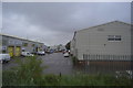
5
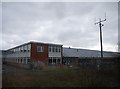
Disused Factory, Hampden Park
Taken from Cross Levels Way.
Image: © Simon Carey
Taken: 2 Jun 2006
0.08 miles

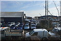
8
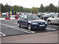
Parking at Comet
Unusual white line parking.
Image: © Oast House Archive
Taken: 24 Sep 2012
0.13 miles