IMAGES TAKEN NEAR TO
Rylstone Road, EASTBOURNE, BN22 7HH
Introduction
This page details the photographs taken nearby to Rylstone Road, BN22 7HH by members of the Geograph project.
The Geograph project started in 2005 with the aim of publishing, organising and preserving representative images for every square kilometre of Great Britain, Ireland and the Isle of Man.

There are currently over 7.5m images from over14,400 individuals and you can help contribute to the project by visiting https://www.geograph.org.uk
Image Map
Images are licensed for reuse under creativecommons.org/licenses/by-sa/2.0
Notes
- Clicking on the map will re-center to the selected point.
- The higher the marker number, the further away the image location is from the centre of the postcode.
Image Listing (353 Images Found)
Images are licensed for reuse under creativecommons.org/licenses/by-sa/2.0
Image
Details
Distance
6
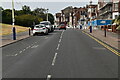
St Lucia & St Margarets
Houses on the Royal Parade, Eastbourne.
Image: © Ian S
Taken: 24 Jan 2016
0.04 miles
7
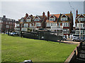
The best British tank ever made
The Centurion Mark III was produced from the end of the Second World War until the early 1960s and saw service from the Korean War until the first Gulf War in the 1990s. That's a service history far in excess of almost another any other fighting vehicle.
Image: © Andy Potter
Taken: 21 Sep 2008
0.04 miles
8
![Eastbourne features [31]](https://s2.geograph.org.uk/geophotos/07/20/01/7200198_e3708d5d_120x120.jpg)
Eastbourne features [31]
At the foot of the glacis of the redoubt sits this cannon, possibly once a part of the weaponry of the fortification.
The redoubt fort is an early 19th century circular fortification, set within a dry moat and outer glacis. It was constructed between 1804 and 1812, to support the contemporary defensive chain of Martello towers, guarding the coastline. The structure is some 225 feet (68 metres) in diameter and some 40 feet (12 metres) tall. The redoubt displays a wide range of original components and associated features. It was reused during World Wars I and II. Listed, grade II, with details at: https://historicengland.org.uk/listing/the-list/list-entry/1043662 A Scheduled Ancient Monument with much history and detail at: https://historicengland.org.uk/listing/the-list/list-entry/1017358
Eastbourne is a town and seaside resort on the south coast of East Sussex, some 54 miles south of London and about 19 miles east of Brighton. Although there is evidence of settlement from the Stone Age onwards, Eastbourne remained an area of small rural settlements until the railway arrived in 1849. A resort, built "for gentlemen by gentlemen", was planned and the town's growth accelerated from a population of less than 4,000 in 1851 to nearly 35,000 by 1891. Tourism is a large and important part of the economy of the town.
Image: © Michael Dibb
Taken: 3 May 2022
0.04 miles
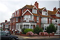
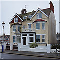
10
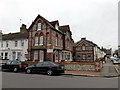
Bella Vista Hotel, Eastbourne
The Bella Vista was originally built as a Victorian school Headmaster's house.
Image: © PAUL FARMER
Taken: 6 Apr 2014
0.05 miles