IMAGES TAKEN NEAR TO
Regnum Close, EASTBOURNE, BN22 0XH
Introduction
This page details the photographs taken nearby to Regnum Close, BN22 0XH by members of the Geograph project.
The Geograph project started in 2005 with the aim of publishing, organising and preserving representative images for every square kilometre of Great Britain, Ireland and the Isle of Man.

There are currently over 7.5m images from over14,400 individuals and you can help contribute to the project by visiting https://www.geograph.org.uk
Image Map
Images are licensed for reuse under creativecommons.org/licenses/by-sa/2.0
Notes
- Clicking on the map will re-center to the selected point.
- The higher the marker number, the further away the image location is from the centre of the postcode.
Image Listing (7 Images Found)
Images are licensed for reuse under creativecommons.org/licenses/by-sa/2.0
Image
Details
Distance
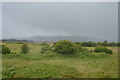
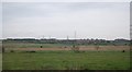
1
Footpath off Hazelwood Avenue Lower Willingdon
Image: © Dave Spicer
Taken: 18 Sep 2013
0.05 miles
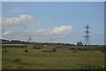
5
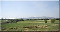
Willingdon Levels
The South Downs can be seen in the background.
Image: © N Chadwick
Taken: 24 Apr 2010
0.22 miles
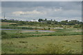
6
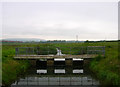
Sluice, Willingdon and West Langney Sewer
One of the many drainage ditches that cross Willingdon Level. Coombe Hill is in the background.
Image: © Simon Carey
Taken: 2 Jun 2006
0.24 miles