IMAGES TAKEN NEAR TO
Friston Avenue, EASTBOURNE, BN22 0EJ
Introduction
This page details the photographs taken nearby to Friston Avenue, BN22 0EJ by members of the Geograph project.
The Geograph project started in 2005 with the aim of publishing, organising and preserving representative images for every square kilometre of Great Britain, Ireland and the Isle of Man.

There are currently over 7.5m images from over14,400 individuals and you can help contribute to the project by visiting https://www.geograph.org.uk
Image Map
Images are licensed for reuse under creativecommons.org/licenses/by-sa/2.0
Notes
- Clicking on the map will re-center to the selected point.
- The higher the marker number, the further away the image location is from the centre of the postcode.
Image Listing (133 Images Found)
Images are licensed for reuse under creativecommons.org/licenses/by-sa/2.0
Image
Details
Distance
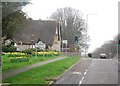
1
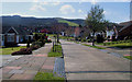
Wrestwood Avenue, Willingdon, East Sussex
With the South Downs in the background.
Image: © Kevin Gordon
Taken: 13 Apr 2008
0.07 miles
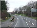
2

Eastbourne Rd
The A2270 out of Eastbourne.
Image: © N Chadwick
Taken: 31 Mar 2011
0.08 miles
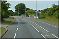
6
Entering Willingdon, Eastbourne Rd
Leaving Eastbourne on the A2270.
Image: © N Chadwick
Taken: 31 Mar 2011
0.15 miles
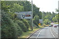
7
Entering Eastbourne, Willingdon Rd, A2270
Image: © N Chadwick
Taken: 3 Jul 2015
0.15 miles
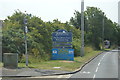
8

Friston Avenue, Willingdon, East Sussex
The turning for Wrestwood Avenue is on the right just by the letter box.
Image: © Kevin Gordon
Taken: 13 Apr 2008
0.15 miles
9
![Willingdon houses [2]](https://s2.geograph.org.uk/geophotos/07/19/71/7197134_1850a0f6_120x120.jpg)
Willingdon houses [2]
Glimpsed at the end of a long driveway off Church Street, is Haystoun House. Built circa 1860 of stuccoed brick under a hipped slate roof. There is a wing with a recessed veranda of 2 columns, now Haystoun Cottage, a separate dwelling. There is another image of the house at Image Listed, grade II, with details at: https://historicengland.org.uk/listing/the-list/list-entry/1184967
Once isolated villages, Upper Willingdon and Lower Willingdon, are now part of the built-up area of Eastbourne. Set on a spur at the foot of the South Downs, the village lies astride the A22 road, about 1 mile south of Polegate. There is evidence of occupation since the pre-Saxon age.
Image: © Michael Dibb
Taken: 10 May 2022
0.16 miles
10
![Willingdon houses [3]](https://s3.geograph.org.uk/geophotos/07/19/71/7197135_256e1b19_120x120.jpg)
Willingdon houses [3]
A glimpse of Haystoun House, seen from Lodge Avenue. Built circa 1860 of stuccoed brick under a hipped slate roof. There is a wing with a recessed veranda of 2 columns, now Haystoun Cottage, a separate dwelling. There is another image of the house at Image Listed, grade II, with details at: https://historicengland.org.uk/listing/the-list/list-entry/1184967
Once isolated villages, Upper Willingdon and Lower Willingdon, are now part of the built-up area of Eastbourne. Set on a spur at the foot of the South Downs, the village lies astride the A22 road, about 1 mile south of Polegate. There is evidence of occupation since the pre-Saxon age.
Image: © Michael Dibb
Taken: 10 May 2022
0.16 miles