
IMAGES TAKEN NEAR TO
Steine Street, BRIGHTON, BN2 1TE
Introduction
This page details the photographs taken nearby to Steine Street, BN2 1TE by members of the Geograph project.
The Geograph project started in 2005 with the aim of publishing, organising and preserving representative images for every square kilometre of Great Britain, Ireland and the Isle of Man.

There are currently over 7.5m images from over14,400 individuals and you can help contribute to the project by visiting https://www.geograph.org.uk
Image Map
Images are licensed for reuse under creativecommons.org/licenses/by-sa/2.0
Notes
- Clicking on the map will re-center to the selected point.
- The higher the marker number, the further away the image location is from the centre of the postcode.
Image Listing (2040 Images Found)
Images are licensed for reuse under creativecommons.org/licenses/by-sa/2.0
Image
Details
Distance
1
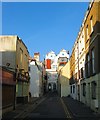
Steine Street, Brighton
A narrow residential street that runs between Marine Parade and St james's Street and was constructed in the late 1770s. On the western side to the left is a former pub, the Three and Ten which was previously known as the Queen's Head whose pub sign displayed a portait of Freddie Mercury for a brief period in the 1990s. The houses on the right, the eastern side, were built in 1986 on the site of a former Southdown bus depot which had occupied the spot from 1916. To negotitae the narrow streets the buses would enter via Manchester Street and leave the depot in Steine Street. Southdown transferred most of its operations to an expanded site in Freshfield Road in the 1960s with this site just used for coaches until its closure. See https://www.flickr.com/photos/30999979@N05/16196948672 for an image taken in 1976.
Image: © Simon Carey
Taken: 11 Oct 2015
0.01 miles
2
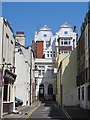
Steine Street, BN2
Shows a ghost sign for The Queen's Head on Image
Image: © Mike Quinn
Taken: 22 May 2012
0.01 miles
3
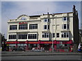
Harry Ramsden's, Marina Parade, Brighton
At the junction with Steine Street
Image: © Robin Sones
Taken: 6 Jun 2010
0.01 miles
5
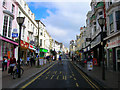
St James' Street
Head south down Princes Street then Old Steine until the junction of St James' Street is reached. Constructed from 1790 along another leakway that divided Little Laine between Upper and Cliff Furlongs respectively to serve the new developments in the Eastcliff area of town. It marks a divide between the higher class residences to the south with the artisan and worker based areas to the north. Still a major shopping area that serves the still poorer areas to the north and gay community.
Click on the link to take you to the next page. http://www.geograph.org.uk/photo/231455
Image: © Simon Carey
Taken: 1 Sep 2006
0.02 miles
6
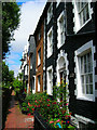
St James' Place
A narrow passage way near the bottom of St James' Street leads to St James' Place a small passage with six late 19th century houses all cobble fronted with the exception of number 2 which was refaced in Victorian times. Access through a gate is for residents only.
Click on the link to take you to the next page. http://www.geograph.org.uk/photo/231465
Image: © Simon Carey
Taken: 1 Sep 2006
0.02 miles
7
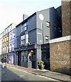
The Plotting Parlour, Steine Street, Brighton
Oppened as The Brighton Packet Inn in 1822, became The Aquarium in 1873 before acquiring its current name in 2014.
Image: © Simon Carey
Taken: 2 Jan 2025
0.02 miles
9
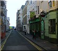
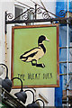
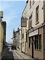
Manchester Street, Brighton
A residential street that runs between St James's Street and Marine parade that was developed in the 1780s. The pub on the right dates from around the 1790s and was known as the Star Inn until 2011 when it changed to its current name, The Mucky Duck. Beyond are a block of flats built in the 1980s on the old entrance to Steine Street bus station.
Image: © Simon Carey
Taken: 11 Oct 2015
0.02 miles
10
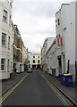
Manchester Street
Lying between Marine Parade, the A259, and St James's Street, the B2118. the street was developed in the late 18th century as Brighton began expanding eastwards from the Old Steine. The building on the right contains the Jooglebury Playhouse which was the original location for Komedia which moved to Image in 1998.
Image: © Simon Carey
Taken: 7 Oct 2011
0.02 miles