IMAGES TAKEN NEAR TO
Old Wish Road, EASTBOURNE, BN21 4JZ
Introduction
This page details the photographs taken nearby to Old Wish Road, BN21 4JZ by members of the Geograph project.
The Geograph project started in 2005 with the aim of publishing, organising and preserving representative images for every square kilometre of Great Britain, Ireland and the Isle of Man.

There are currently over 7.5m images from over14,400 individuals and you can help contribute to the project by visiting https://www.geograph.org.uk
Image Map
Images are licensed for reuse under creativecommons.org/licenses/by-sa/2.0
Notes
- Clicking on the map will re-center to the selected point.
- The higher the marker number, the further away the image location is from the centre of the postcode.
Image Listing (296 Images Found)
Images are licensed for reuse under creativecommons.org/licenses/by-sa/2.0
Image
Details
Distance
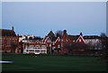
1
![Eastbourne features [49]](https://s1.geograph.org.uk/geophotos/07/21/82/7218261_3af01199_120x120.jpg)
Eastbourne features [49]
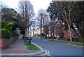
Grange Road, seen in this early morning view, is a typical residential street in Eastbourne.
Eastbourne is a town and seaside resort on the south coast of East Sussex, some 54 miles south of London and about 19 miles east of Brighton. Although there is evidence of settlement from the Stone Age onwards, Eastbourne remained an area of small rural settlements until the railway arrived in 1849. A resort, built "for gentlemen by gentlemen", was planned and the town's growth accelerated from a population of less than 4,000 in 1851 to nearly 35,000 by 1891. Tourism is a large and important part of the economy of the town.
Image: © Michael Dibb
Taken: 5 May 2022
0.02 miles
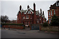
5
Cricket Pavilion, Eastbourne College
An independent school founded by the Duke of Devonshire in 1867.
Image: © N Chadwick
Taken: 12 Apr 2010
0.04 miles
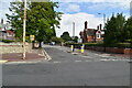
6
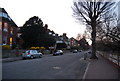
Carlisle Rd looking east
An area of Edwardian housing.
Image: © N Chadwick
Taken: 12 Apr 2010
0.04 miles
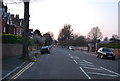
7
Grange Rd in front of Eastbourne College
Image: © N Chadwick
Taken: 12 Apr 2010
0.04 miles
8
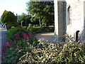
The garden of All Saints Church from Grange Road
All Saints was built between 1878 and 1880. This view looks across its garden past the tower to Carlisle Road on the far side.
Image: © Marathon
Taken: 10 Jun 2015
0.04 miles
9
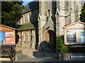
The entrance to All Saints Church
All Saints was built between 1878 and 1880. This view looks from the corner of Grange Road and Carlisle Road to the main entrance at the foot of the tower.
Image: © Marathon
Taken: 10 Jun 2015
0.04 miles
10
![Eastbourne churches [8]](https://s1.geograph.org.uk/geophotos/07/20/10/7201033_83144267_120x120.jpg)
Eastbourne churches [8]
A richly moulded doorway leading into the tower.
The Anglican parish church of All Saints in Carlisle Road is a large church with a fine tower. Originally built in 1879, only the tower and vestry remained standing after a major fire in 1927. The church was rebuilt in 1929 in a Gothic style. Constructed of a mix of coursed and snecked rusticated stone with freestone dressings under Westmorland slate roofs, with a wooden shingled roof to the tower. Listed, grade II, with details at: https://historicengland.org.uk/listing/the-list/list-entry/1353110
Eastbourne is a town and seaside resort on the south coast of East Sussex, some 54 miles south of London and about 19 miles east of Brighton. Although there is evidence of settlement from the Stone Age onwards, Eastbourne remained an area of small rural settlements until the railway arrived in 1849. A resort, built "for gentlemen by gentlemen", was planned and the town's growth accelerated from a population of less than 4,000 in 1851 to nearly 35,000 by 1891. Tourism is a large and important part of the economy of the town.
Image: © Michael Dibb
Taken: 5 May 2022
0.04 miles