IMAGES TAKEN NEAR TO
Grange Road, EASTBOURNE, BN21 4HG
Introduction
This page details the photographs taken nearby to Grange Road, BN21 4HG by members of the Geograph project.
The Geograph project started in 2005 with the aim of publishing, organising and preserving representative images for every square kilometre of Great Britain, Ireland and the Isle of Man.

There are currently over 7.5m images from over14,400 individuals and you can help contribute to the project by visiting https://www.geograph.org.uk
Image Map
Images are licensed for reuse under creativecommons.org/licenses/by-sa/2.0
Notes
- Clicking on the map will re-center to the selected point.
- The higher the marker number, the further away the image location is from the centre of the postcode.
Image Listing (328 Images Found)
Images are licensed for reuse under creativecommons.org/licenses/by-sa/2.0
Image
Details
Distance
2
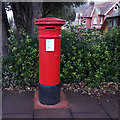
Unmarked postbox
On the junction of Jevington Gardens and Grange Road, Eastbourne.
Image: © Ian S
Taken: 24 Jan 2016
0.04 miles
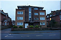
3
Highview Court
On Silverdale Road, Eastbourne.
Image: © Ian S
Taken: 24 Jan 2016
0.05 miles
5
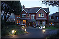
Demolition in progress of a former grand villa on Grange Road Eastbourne
Image: © Steve Fareham
Taken: 5 Jul 2015
0.05 miles
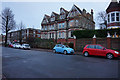
9
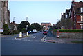
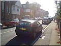
Grange Rd looking south
An area of Edwardian houses.
Image: © N Chadwick
Taken: 12 Apr 2010
0.08 miles