IMAGES TAKEN NEAR TO
Charleston Road, EASTBOURNE, BN21 1SE
Introduction
This page details the photographs taken nearby to Charleston Road, BN21 1SE by members of the Geograph project.
The Geograph project started in 2005 with the aim of publishing, organising and preserving representative images for every square kilometre of Great Britain, Ireland and the Isle of Man.

There are currently over 7.5m images from over14,400 individuals and you can help contribute to the project by visiting https://www.geograph.org.uk
Image Map
Images are licensed for reuse under creativecommons.org/licenses/by-sa/2.0
Notes
- Clicking on the map will re-center to the selected point.
- The higher the marker number, the further away the image location is from the centre of the postcode.
Image Listing (176 Images Found)
Images are licensed for reuse under creativecommons.org/licenses/by-sa/2.0
Image
Details
Distance
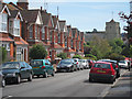
1
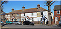
Green Street, Eastbourne, East Sussex
This was once a track leading up to Green Street Barn on the South Downs. Victorian Local Historian Walter Budgen believed that this was a Roman Road.
Image: © Kevin Gordon
Taken: 29 Mar 2008
0.06 miles
4
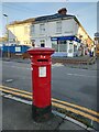
Victorian Postbox, Salehurst Road Eastbourne
Image: © PAUL FARMER
Taken: 3 Nov 2021
0.11 miles
5
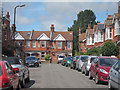
Bakewell Road
Looking down the terraced residential road with St Mary's church seen in the distance.
Image: © Oast House Archive
Taken: 16 Aug 2011
0.12 miles
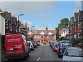
7
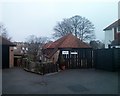
Old Motcombe Mews, Motcombe Road, Eastbourne
Image: © PAUL FARMER
Taken: 25 Jan 2014
0.13 miles