IMAGES TAKEN NEAR TO
Green Street, EASTBOURNE, BN21 1QN
Introduction
This page details the photographs taken nearby to Green Street, BN21 1QN by members of the Geograph project.
The Geograph project started in 2005 with the aim of publishing, organising and preserving representative images for every square kilometre of Great Britain, Ireland and the Isle of Man.

There are currently over 7.5m images from over14,400 individuals and you can help contribute to the project by visiting https://www.geograph.org.uk
Image Map
Images are licensed for reuse under creativecommons.org/licenses/by-sa/2.0
Notes
- Clicking on the map will re-center to the selected point.
- The higher the marker number, the further away the image location is from the centre of the postcode.
Image Listing (168 Images Found)
Images are licensed for reuse under creativecommons.org/licenses/by-sa/2.0
Image
Details
Distance
3
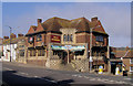
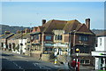
Tally Ho, 42, Church Street, Junction of Green Street, Eastbourne, East Sussex
Although the Tally Ho has a hunting theme, it may have been named after the Tallo Ho ship which was wrecked at Eastbourne in 1887. The spacious pub is in an interesting 1930s design and is now also home to a popular steakhouse.
Image: © Kevin Gordon
Taken: 29 Mar 2008
0.04 miles
4
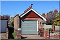
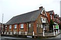
Greenfield Methodist Church, Eastbourne
Image: © PAUL FARMER
Taken: 14 Sep 2017
0.04 miles
5
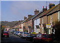
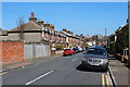
Bradford Street (west) Eastbourne, East Sussex
Bradford street is crossed by Green Street and this is the western section of the road.
Image: © Kevin Gordon
Taken: 29 Mar 2008
0.04 miles
8
![Eastbourne buildings [56]](https://s2.geograph.org.uk/geophotos/07/21/93/7219362_f40e361a_120x120.jpg)
Eastbourne buildings [56]
The Tally Ho public house, number 40 Church Street, was built in a distinctive vernacular revival manner in 1927, replacing an earlier public house on the same site. Constructed of red brick and stone, with tile, flint, metal and plaster decorative panels, all under tile roofs. Listed, grade II, with much history and detail at: https://historicengland.org.uk/listing/the-list/list-entry/1415582
Eastbourne is a town and seaside resort on the south coast of East Sussex, some 54 miles south of London and about 19 miles east of Brighton. Although there is evidence of settlement from the Stone Age onwards, Eastbourne remained an area of small rural settlements until the railway arrived in 1849. A resort, built "for gentlemen by gentlemen", was planned and the town's growth accelerated from a population of less than 4,000 in 1851 to nearly 35,000 by 1891. Tourism is a large and important part of the economy of the town.
Image: © Michael Dibb
Taken: 9 May 2022
0.05 miles
10
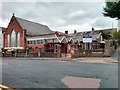
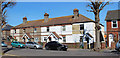
Church Street towards East Dean Road, Eastbourne, East Sussex
The hill in the background is Crapham Hill. The beach pebbles laid in concrete appear to be an effort to prevent people from crossing the road here, although there is a gap alongside the bus stop.
Image: © Kevin Gordon
Taken: 29 Mar 2008
0.05 miles