IMAGES TAKEN NEAR TO
Church Lane, EASTBOURNE, BN21 1HU
Introduction
This page details the photographs taken nearby to Church Lane, BN21 1HU by members of the Geograph project.
The Geograph project started in 2005 with the aim of publishing, organising and preserving representative images for every square kilometre of Great Britain, Ireland and the Isle of Man.

There are currently over 7.5m images from over14,400 individuals and you can help contribute to the project by visiting https://www.geograph.org.uk
Image Map
Images are licensed for reuse under creativecommons.org/licenses/by-sa/2.0
Notes
- Clicking on the map will re-center to the selected point.
- The higher the marker number, the further away the image location is from the centre of the postcode.
Image Listing (340 Images Found)
Images are licensed for reuse under creativecommons.org/licenses/by-sa/2.0
Image
Details
Distance
1
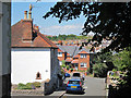
![Eastbourne houses [35]](https://s3.geograph.org.uk/geophotos/07/21/94/7219403_4e49e05a_120x120.jpg)
Eastbourne houses [35]
Numbers 3 to 5 Church Lane were originally a row of three cottages, now one house. Possibly built in the 18th century of cobbles, partly rendered under a hipped tile roof. Listed, grade II, with details at: https://historicengland.org.uk/listing/the-list/list-entry/1043670
Eastbourne is a town and seaside resort on the south coast of East Sussex, some 54 miles south of London and about 19 miles east of Brighton. Although there is evidence of settlement from the Stone Age onwards, Eastbourne remained an area of small rural settlements until the railway arrived in 1849. A resort, built "for gentlemen by gentlemen", was planned and the town's growth accelerated from a population of less than 4,000 in 1851 to nearly 35,000 by 1891. Tourism is a large and important part of the economy of the town.
Image: © Michael Dibb
Taken: 9 May 2022
0.01 miles
2
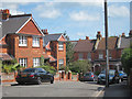
Church Lane
Dead end road by the church. Looking from High Street junction which is close to vehicles.
Image: © Oast House Archive
Taken: 4 Jul 2011
0.01 miles
3
The Flint House, Church Lane, Eastbourne
Image: © PAUL FARMER
Taken: 15 Sep 2013
0.01 miles
5
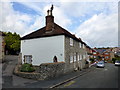
![Eastbourne houses [34]](https://s1.geograph.org.uk/geophotos/07/21/93/7219397_c5017ce0_120x120.jpg)
Eastbourne houses [34]
Numbers 1 and 2 Church Lane were possibly built in the 18th century. Constructed of cobbles with brick dressings and quoins, under a hipped tile roof. Listed, grade II, with details at: https://historicengland.org.uk/listing/the-list/list-entry/1353111
Eastbourne is a town and seaside resort on the south coast of East Sussex, some 54 miles south of London and about 19 miles east of Brighton. Although there is evidence of settlement from the Stone Age onwards, Eastbourne remained an area of small rural settlements until the railway arrived in 1849. A resort, built "for gentlemen by gentlemen", was planned and the town's growth accelerated from a population of less than 4,000 in 1851 to nearly 35,000 by 1891. Tourism is a large and important part of the economy of the town.
Image: © Michael Dibb
Taken: 9 May 2022
0.01 miles
6
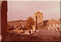
St Mary the Virgin Parish Church, Church Street, Eastbourne
Image: © PAUL FARMER
Taken: 25 Sep 2017
0.01 miles
7
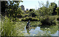
Motcombe Gardens
Motcombe Gardens, Ocklynge in Eastbourne’s Old Town. St Mary’s Parish church can been seen in the background. The statue of Neptune has unfortunately lost his trident and now looks as though he’s shaking his fist!
Image: © Andrew Huggett
Taken: 7 Aug 2004
0.02 miles
8
Parsonage Road
The road turns right where it turns into Church Lane, and connects back to Church Street where it is blocked off to vehicles.
Image: © Oast House Archive
Taken: 16 Aug 2011
0.02 miles
9
St Mary's Church 1979 with Archaeological Excavations
Taken at the Eastbourne Urban Medieval Excavation Project which was excavating the Jesus House site at this spot. The huts used by the archaeologists can be seen to the left of the large spoil heap. This site is now occupied by St Mary's House Retirement Home.
Image: © Kevin Gordon
Taken: Unknown
0.03 miles
10
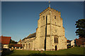
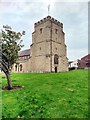
St.Mary's church
Old Town parish church with a large Norman tower
Image: © Richard Croft
Taken: 18 Jun 2012
0.03 miles