IMAGES TAKEN NEAR TO
Wannock Avenue, EASTBOURNE, BN20 9RG
Introduction
This page details the photographs taken nearby to Wannock Avenue, BN20 9RG by members of the Geograph project.
The Geograph project started in 2005 with the aim of publishing, organising and preserving representative images for every square kilometre of Great Britain, Ireland and the Isle of Man.

There are currently over 7.5m images from over14,400 individuals and you can help contribute to the project by visiting https://www.geograph.org.uk
Image Map
Images are licensed for reuse under creativecommons.org/licenses/by-sa/2.0
Notes
- Clicking on the map will re-center to the selected point.
- The higher the marker number, the further away the image location is from the centre of the postcode.
Image Listing (15 Images Found)
Images are licensed for reuse under creativecommons.org/licenses/by-sa/2.0
Image
Details
Distance
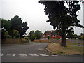
1

Old Direction Sign - Signpost by Jevington Road, Wannock
Black iron cap finial - 3 arms; East Sussex wood by the UC road, in parish of Willingdon and Jevington (Wealden District), junction of Wannock Lane with Jevington Road, on grass triangle at junction.
Surveyed
Milestone Society National ID: SX_TQ5703
Image: © Milestone Society
Taken: Unknown
0.06 miles
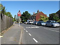
5
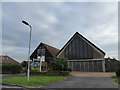
Jevington Road
Running through the small hamlet of Wannock with the village hall, built in 1974 to replace the former Jubilee Mission Hall constructed in 1887, on the right. The hamlet was marked as Walnut Street on both Yeakell & Gardner's 1783 map and the first OS issue of 1813. Although having been in existence for far longer it has now become a suburb of nearby Polegate.
Image: © Simon Carey
Taken: 24 Jan 2009
0.09 miles
7
St Wilfrid, Lower Willingdon: early December 2015
Image: © Basher Eyre
Taken: 7 Dec 2015
0.17 miles
9

Willingdon Community School taken from the Downs
The 3 school buses are waiting to collect the students, some of whom are going to miss them because they are still on the Downs finishing the annual sponsored walk!
Image: © Dave Creighton
Taken: 25 Sep 2008
0.17 miles
10
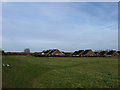
Paragon Fields
Open space to the rear of houses in Wannock Gardens (in view) and The Paragon, Wannock Lane. The footpath from Wannock to Willingdon also runs through it.
Image: © Simon Carey
Taken: 24 Jan 2009
0.17 miles