IMAGES TAKEN NEAR TO
Longland Road, EASTBOURNE, BN20 8HR
Introduction
This page details the photographs taken nearby to Longland Road, BN20 8HR by members of the Geograph project.
The Geograph project started in 2005 with the aim of publishing, organising and preserving representative images for every square kilometre of Great Britain, Ireland and the Isle of Man.

There are currently over 7.5m images from over14,400 individuals and you can help contribute to the project by visiting https://www.geograph.org.uk
Image Map
Images are licensed for reuse under creativecommons.org/licenses/by-sa/2.0
Notes
- Clicking on the map will re-center to the selected point.
- The higher the marker number, the further away the image location is from the centre of the postcode.
Image Listing (53 Images Found)
Images are licensed for reuse under creativecommons.org/licenses/by-sa/2.0
Image
Details
Distance

4
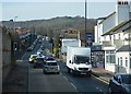
On the way down from Crapham Hill (2)
Too much bottle... not enough skill... or road.
Image: © David Long
Taken: 2 May 2007
0.10 miles
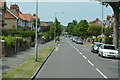
7
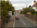
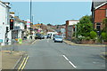
Eastbourne Old Town
Entering Eastbourne via East Dean Road, A259.
Image: © David Dixon
Taken: 5 Aug 2012
0.11 miles